
Back to simple search | Back to advanced search
- Recorded by (obfuscated for security):0013EA168E00196E
- Broad period:MESOLITHIC
You searched for:
-

Image not taken
Record ID: HAMP1399
Object type: BLADE
Broad period: MESOLITHIC
County: Hampshire
Workflow stage: Published ![]()
Tertiary flint blade; light grey. Snapped proximal end. Flake removal scars on dorsal surface. Burnt.
Created on: Monday 1st October 2001
Last updated: Thursday 24th February 2011
Spatial data recorded.
This findspot is known as 'HAMPSHIRE PETERSFIELD', grid reference and parish protected.

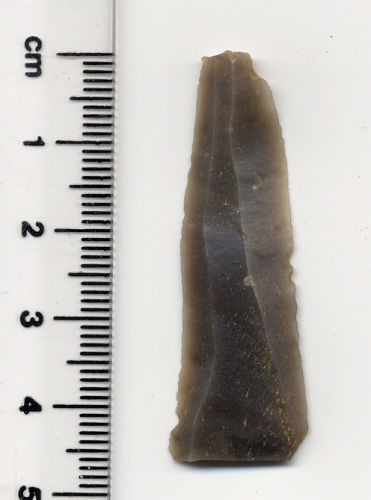
Record ID: HAMP1367
Object type: BLADE
Broad period: MESOLITHIC
County: Hampshire
Workflow stage: Published ![]()
Tertiary flint blade. Grey/black. Parallel flake scars on dorsal surface. Light grey patina.
Created on: Wednesday 12th September 2001
Last updated: Thursday 24th February 2011
Spatial data recorded.
This findspot is known as 'HAMPSHIRE PETERSFIELD', grid reference and parish protected.
-
Image not taken
Record ID: HAMP1368
Object type: FLAKE
Broad period: MESOLITHIC
County: Hampshire
Workflow stage: Published ![]()
Tertiary flint core rejuvenation flake. Grey/black. Parallel flake scars on dorsal surface. Distal end snapped off.
Created on: Wednesday 12th September 2001
Last updated: Thursday 24th February 2011
Spatial data recorded.
This findspot is known as 'HAMPSHIRE PETERSFIELD', grid reference and parish protected.
Record ID: HAMP1321
Object type: BLADE
Broad period: MESOLITHIC
County: Hampshire
Workflow stage: Published ![]()
Black/grey tertiary flint snapped blade. Very parallel flake scars on dorsal surface.
Created on: Thursday 6th September 2001
Last updated: Thursday 24th February 2011
Spatial data recorded.
This findspot is known as 'HAMPSHIRE PETERSFIELD', grid reference and parish protected.
-
Image not taken
Record ID: HAMP1323
Object type: BLADE
Broad period: MESOLITHIC
County: Hampshire
Workflow stage: Published ![]()
Black-grey/orange tertiary flint retouched blade. Parallel flake scars on dorsal surface. Orange colouration. Retouched distal end. Angle of retouch: 40.
Created on: Thursday 6th September 2001
Last updated: Thursday 24th February 2011
Spatial data recorded.
This findspot is known as 'HAMPSHIRE PETERSFIELD', grid reference and parish protected.
-
Image not taken
Record ID: HAMP1327
Object type: FLAKE
Broad period: MESOLITHIC
County: Hampshire
Workflow stage: Published ![]()
Black/grey tertiary flint flake. Retouch on right proximal end. White patina on distal end.
Created on: Thursday 6th September 2001
Last updated: Thursday 24th February 2011
Spatial data recorded.
This findspot is known as 'HAMPSHIRE PETERSFIELD', grid reference and parish protected.

Record ID: HAMP1332
Object type: FLAKE
Broad period: MESOLITHIC
County: Hampshire
Workflow stage: Published ![]()
Black/grey tertiary flint flake. Retouch on right ventral edge. Flake scars on dorsal. White patina appearing. Angle of retouch: 20.
Created on: Thursday 6th September 2001
Last updated: Thursday 24th February 2011
Spatial data recorded.
This findspot is known as 'HAMPSHIRE PETERSFIELD', grid reference and parish protected.
-
Image not taken
Record ID: HAMP855
Object type: DEBITAGE
Broad period: MESOLITHIC
County: Hampshire
Workflow stage: Published ![]()
Created on: Friday 2nd March 2001
Last updated: Thursday 24th February 2011
Spatial data recorded.
This findspot is known as 'HAMPSHIRE OLIVERS BATTERY', grid reference and parish protected.
-
Image not taken
Record ID: HAMP96
Object type: FLAKE
Broad period: MESOLITHIC
County: Hampshire
Workflow stage: Published ![]()
Dark brown steep-sided scraper, remaining cortex (striking platform). Clear evidence of working along the outer edges. Struck in one direction only, towards the outer edge. Possible blade core that has been reworked.
Created on: Thursday 16th September 1999
Last updated: Thursday 24th February 2011
Spatial data recorded.
This findspot is known as 'HAMPSHIRE HORNDEAN', grid reference and parish protected.
Records per page: 10 20 40 100
Sort your search by:
Which direction?
Total results available: 9
Search server index: asgard
You are viewing records: 1 - 9.
Search statistics
- Total quantity: 9
- Mean quantity: 1.000
- Maximum: 1
Filter your search
Object type
County of origin
Broad period
Institution
Material
Workflow
1 - 9 of 9 records.
About Us
About our Site

Find us
The British Museum, Great Russell Street, London WC1B 3DG.
T: +44(0) 20 73238618