
Back to simple search | Back to advanced search
- Free text search:Milborne Port
- Object type:FLAKE
You searched for:

Record ID: SOM-A78BF7
Object type: FLAKE
Broad period: NEOLITHIC
County: Somerset
Workflow stage: Awaiting validation ![]()
Four flint waste flakes of probable Neolithic to early Bronze Age date. Two of the flakes are secondary (with some remaining cortex) and two are tertiary (with no cortex). All four show signs of having been struck but have not been further worked.
Total weight: 26.8g
Created on: Wednesday 26th September 2007
Last updated: Thursday 24th February 2011
Spatial data recorded.
This findspot is known as 'Milborne Port', grid reference and parish protected.
-

Image not taken
Record ID: SOMDOR-6003B5
Object type: FLAKE
Broad period: NEOLITHIC
County: Somerset
Workflow stage: Awaiting validation ![]()
Five flint waste flakes of probable Neolithic to early Bronze Age date. One is secondary and the others are tertiary. All show signs of having been struck but have not been further worked.
Total weight: 6g
Created on: Monday 30th April 2007
Last updated: Thursday 24th February 2011
Spatial data recorded.
This findspot is known as 'Milborne Port', grid reference and parish protected.
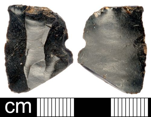
Record ID: SOMDOR-5FDA33
Object type: FLAKE
Broad period: NEOLITHIC
County: Somerset
Workflow stage: Awaiting validation ![]()
A broken flint waste flake of probable Neolithic to early Bronze Age date. At the proximal end of the tertiary flake is the striking platform and below this on the ventral surface is a slight bulb of percussion. Ripples radiate down the ventral surface. There are several flaking scars on the dorsal surface at the flake has broken at a length of 23.9mm. The notch in one lateral side does not appear to be deliberate. The greyish black flint has a low-gloss patina.
Dimensions: 23.9mm by 18.5mm by 4.8mm
Weight: 2.6g
Created on: Monday 30th April 2007
Last updated: Thursday 24th February 2011
Spatial data recorded.
This findspot is known as 'Milborne Port', grid reference and parish protected.
Records per page: 10 20 40 100
Sort your search by:
Which direction?
Total results available: 3
Search server index: valhalla
You are viewing records: 1 - 3.
Search statistics
- Total quantity: 10
- Mean quantity: 3.333
- Maximum: 5
Filter your search
Object type
County of origin
Broad period
Institution
Material
Workflow
1 - 3 of 3 records.
About Us
About our Site

Find us
The British Museum, Great Russell Street, London WC1B 3DG.
T: +44(0) 20 73238618