
Back to simple search | Back to advanced search
- Material:Stone
- Object type:WHETSTONE
- Broad period:EARLY MEDIEVAL
- Institution:LANCUM
You searched for:

Record ID: LANCUM-9379A7
Object type: WHETSTONE
Broad period: EARLY MEDIEVAL
County: Cumbria
Workflow stage: Awaiting validation ![]()
Possibly a whetstone of early medieval date, c. 9th-11th century. Rectangular in shape and cross-section; very smooth sides.
Created on: Wednesday 15th March 2017
Last updated: Thursday 8th June 2017
Spatial data recorded.
This findspot is known as 'Alston Moor', grid reference and parish protected.

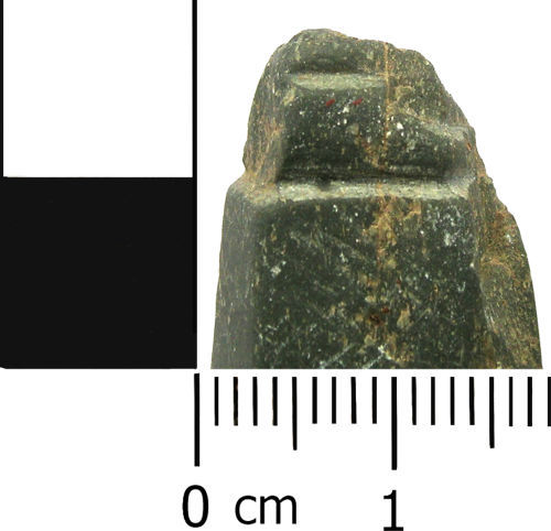
Record ID: LANCUM-555A06
Object type: WHETSTONE
Broad period: EARLY MEDIEVAL
County: Lincolnshire
Workflow stage: Awaiting validation ![]()
Possibly an Early Medieval whetstone, dating to the period c.AD 410-1066. The whetstone is rectangular in cross-section and broadly rectangular in plan. The top (which may have had a hole for suspension) is missing. The opposide end is faceted, creating a flat-topped rectangular pyramid. The stone is grey-brown in colour, with micaceous inclusions.
Cf. LIN-3D5C6E and LIN-B69761
Created on: Wednesday 9th April 2014
Last updated: Wednesday 29th June 2016
Spatial data recorded.
This findspot is known as 'Spilsby', grid reference and parish protected.
Record ID: LANCUM-FF4A27
Object type: WHETSTONE
Broad period: EARLY MEDIEVAL
County: Lancashire
Workflow stage: Awaiting validation ![]()
Probably a whetstone dating from the early medieval period. The object is roughly rectangular in shape and has a rectangular cross section. The surface on one side is rougher than on the other three sides which are very smooth. There are two parallel 'cuts' around the top part of the object which is where a string may have been attached to it. There is no evidence of a perforation.
Created on: Friday 10th January 2014
Last updated: Wednesday 5th February 2014
Spatial data recorded.
This findspot is known as 'Carnforth', grid reference and parish protected.
Records per page: 10 20 40 100
Sort your search by:
Which direction?
Total results available: 3
Search server index: objects
You are viewing records: 1 - 3.
Search statistics
- Total quantity: 3
- Mean quantity: 1.000
- Maximum: 1
Filter your search
Object type
County of origin
Broad period
Institution
Material
Workflow
1 - 3 of 3 records.
About Us
About our Site

Find us
The British Museum, Great Russell Street, London WC1B 3DG.
T: +44(0) 20 73238618