
Back to simple search | Back to advanced search
- Secondary identifier (obfuscated for security):0013EA168E00198C
- Institution:LVPL
- Show this many records per page:10
- Direction:asc
- Object type:DAGGER
- Sort:workflow
You searched for:
Record ID: LVPL-FC08C5
Object type: DAGGER
Broad period: MEDIEVAL
County: Staffordshire
Workflow stage: Awaiting validation ![]()
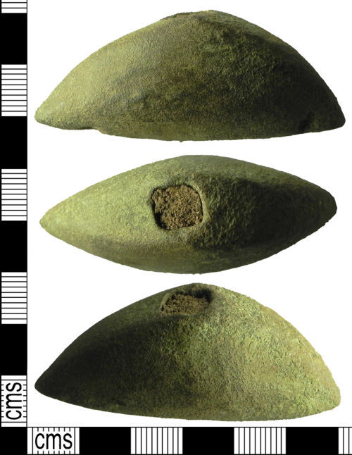
Cast copper alloy dagger pommel dating to the Medieval period. The object is semi-circular in plan and domed. The object is hollow. At the top of the object is a sub-square opening and at the base a wide oval opening. The openings would have allowed the tang of the dagger to pass through the pommel. The opening at the top of the object is 6.67mm wide and 6.06mm in length. At the base of the object the opening measures 23.10mm in width and 6.81mm in length. At each end of the base of the object is a circular depression for attachment.
The object has a brownish green patina. …
Created on: Thursday 2nd September 2010
Last updated: Thursday 30th September 2010
Spatial data recorded.
This findspot is known as 'Ipstones', grid reference and parish protected.

Record ID: LVPL-F7E419
Object type: DAGGER
Broad period: BRONZE AGE
County: Bolton
Workflow stage: Awaiting validation ![]()
A flaked flint dagger of early Bronze Age date, 2,500-1,500BC. The object is a pointed oval in plan and lozenge shaped in cross-section. The flint is flaked on each face with covering retouch. Along each long edge and around the point is short, parallel low-angle retouch. The implement has been made on a grey-brown to dark grey flint.
Dimensions: 141mm in lenght, 47mm in width (at centre), 6mm thick (at centre), 10mm in width (at the point), 14mm in width (at the butt end).
A similar dagger which has been recorded on the PAS database is SF-AFF8C5, https://finds.org.uk/database/a…
Created on: Friday 8th July 2016
Last updated: Thursday 14th July 2016
Spatial data recorded.
This findspot is known as 'Horwich', grid reference and parish protected.
Records per page: 10 20 40 100
Sort your search by:
Which direction?
Total results available: 2
Search server index: valhalla
You are viewing records: 1 - 2.
Search statistics
- Total quantity: 2
- Mean quantity: 1.000
- Maximum: 1
Filter your search
Object type
County of origin
Broad period
Institution
Material
Workflow
1 - 2 of 2 records.
About Us
About our Site

Find us
The British Museum, Great Russell Street, London WC1B 3DG.
T: +44(0) 20 73238618