
Back to simple search | Back to advanced search
- Secondary identifier (obfuscated for security):0013EA168E00198C
- Broad period:MESOLITHIC
- Direction:asc
- Show this many records per page:10
- Sort:objectType
- Object type:PERFORATED OBJECT
You searched for:
Record ID: LANCUM-0FB014
Object type: PERFORATED OBJECT
Broad period: MESOLITHIC
County: Cumbria
Workflow stage: Published ![]()
Perforated stone object dating from the Early Mesolithic to the Late Neolithic. It is complete and in good shape except for a few abrasions around the outer edge. The implement is a simple one with a generally very uneven donut-shape and a circular central perforation which was probably drilled using a bow-like device and a stick with a rounded point, water and sand. The material which the axe hammer was made from looks like the quartz dolerite from the whin sill which was used to make axe-hammers during the Early Bronze Age (pers. comm. Dr Kevin Leahy). Whin sill deposits can be foun…
Created on: Friday 18th July 2008
Last updated: Friday 22nd April 2016
Spatial data recorded.
This findspot is known as 'Greystoke', grid reference and parish protected.
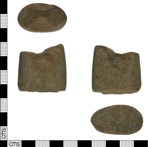
Record ID: YORYM-05794A
Object type: PERFORATED OBJECT
Broad period: MESOLITHIC
County: East Riding of Yorkshire
Workflow stage: Awaiting validation ![]()
An incomplete stone perforated object, dating to from the Mesolithic to the Bronze Age (c.9,000-1,600 BC). The stone is broadly square in plan, but tapers slightly to a terminal with a worn break. A circular concave area is present on each side just before the break, resulting in the oval cross section narrowing at the centre. This suggests that the stone has been partially perforated. One indent has a dark brown patina on some areas. The other terminal is oval in cross section and also terminates in a worn break. Stuart Ogilvy (geologist) has looked at the stone and belives it is a s…
Created on: Monday 7th November 2016
Last updated: Monday 7th November 2016
Spatial data recorded.
This findspot is known as 'Near Driffield', grid reference and parish protected.
Records per page: 10 20 40 100
Sort your search by:
Which direction?
Total results available: 2
Search server index: valhalla
You are viewing records: 1 - 2.
Search statistics
- Total quantity: 2
- Mean quantity: 1.000
- Maximum: 1
Filter your search
Object type
County of origin
Broad period
Institution
Material
Workflow
1 - 2 of 2 records.
About Us
About our Site

Find us
The British Museum, Great Russell Street, London WC1B 3DG.
T: +44(0) 20 73238618