
Back to simple search | Back to advanced search
- Denomination:Farthing (Copper alloy)
- Ruler:William and Mary
- Institution:SOM
You searched for:

Record ID: SOM-AF11FA
Object type: COIN
Broad period: POST MEDIEVAL
County: Hampshire
Workflow stage: Awaiting validation ![]()
A Post Medieval tin farthing of William and Mary dating to AD1690. The edge is badly abraided, and the edge inscription is illegible. Spink (2002: 328) no. 3451.
Created on: Thursday 4th May 2017
Last updated: Thursday 4th May 2017
Spatial data recorded.
This findspot is known as 'Fyfield CP', grid reference and parish protected.

Record ID: SOM-6DDADB
Object type: COIN
Broad period: POST MEDIEVAL
County: Somerset
Workflow stage: Awaiting validation ![]()
A copper alloy post-medieval farthing of William and Mary dating to AD 1694. Cf. Spink p.329, no.3453.
Created on: Friday 21st August 2015
Last updated: Thursday 3rd September 2015
Spatial data recorded.
This findspot is known as 'Misterton', grid reference and parish protected.
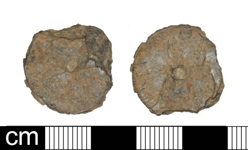
Record ID: SOM-F6FF26
Object type: COIN
Broad period: POST MEDIEVAL
County: Somerset
Workflow stage: Awaiting validation ![]()
Post Medieval tin farthing with a central copper plug of William and Mary dating to AD 1690 to 1692, large cuirassed busts, edge and date illegible, Spink 3451. The edge is badly abraded.
Created on: Tuesday 28th April 2015
Last updated: Wednesday 29th April 2015
Spatial data recorded.
This findspot is known as 'Thornfalcon CP', grid reference and parish protected.
-

Image not taken
Record ID: SOM-7E49B4
Object type: COIN
Broad period: POST MEDIEVAL
County: Somerset
Workflow stage: Awaiting validation ![]()
Post Medieval copper alloy farthing of William III and Mary II (1689-1694), date illegible, 1694
AD, Spink 3453.
Created on: Thursday 19th July 2012
Last updated: Thursday 19th July 2012
Spatial data recorded.
This findspot is known as 'Near Wells', grid reference and parish protected.
Records per page: 10 20 40 100
Sort your search by:
Which direction?
Total results available: 4
Search server index: objects
You are viewing records: 1 - 4.
Search statistics
- Total quantity: 4
- Mean quantity: 1.000
- Maximum: 1
Filter your search
Object type
County of origin
Broad period
Institution
Ruler/issuer
Denomination
Mint
Material
Workflow
1 - 4 of 4 records.
About Us
About our Site

Find us
The British Museum, Great Russell Street, London WC1B 3DG.
T: +44(0) 20 73238618