
Back to simple search | Back to advanced search
- Createdby:285
- Created after: Monday 1st January 2007
- Created before: Monday 31st December 2007
- Ruler:Tetricus I
- Institution:LANCUM
- ReeceID:Period 13: Gallienus sole reign to Aurelian
You searched for:

Record ID: LANCUM-6C4095
Object type: COIN
Broad period: ROMAN
County: Gloucestershire
Workflow stage: Awaiting validation ![]()
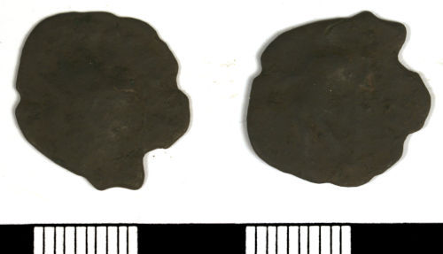
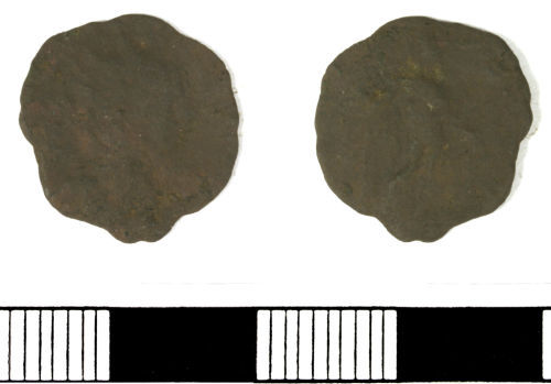
Local copy of a late Roman radiate of Tetricus I or II dating from c. AD270-273.
Created on: Wednesday 5th December 2007
Last updated: Thursday 24th February 2011
Spatial data recorded.
This findspot is known as 'Gloucester', grid reference and parish protected.
Record ID: LANCUM-6C2C57
Object type: COIN
Broad period: ROMAN
County: Gloucestershire
Workflow stage: Awaiting validation ![]()
Local copy of a radiate of Tetricus I dating from c. AD270-273.
Created on: Wednesday 5th December 2007
Last updated: Thursday 24th February 2011
Spatial data recorded.
This findspot is known as 'Gloucester', grid reference and parish protected.

Record ID: LANCUM-6A1EF4
Object type: COIN
Broad period: ROMAN
County: Gloucestershire
Workflow stage: Awaiting validation ![]()
Late Roman radiate/antoninianus of Tetricus I or II dating from c. AD271-274.
Created on: Wednesday 5th December 2007
Last updated: Thursday 24th February 2011
Spatial data recorded.
This findspot is known as 'Gloucester', grid reference and parish protected.
Record ID: LANCUM-2F2284
Object type: COIN
Broad period: ROMAN
County: Gloucestershire
Workflow stage: Awaiting validation ![]()
Late Roman radiate copy of Tetricus I dating from AD271-273.
[MARS VICTOR] RIC V (Tetricus I), 94.
Created on: Sunday 2nd December 2007
Last updated: Thursday 24th February 2011
Spatial data recorded.
This findspot is known as 'Gloucester', grid reference and parish protected.

Record ID: LANCUM-2F13C0
Object type: COIN
Broad period: ROMAN
County: Gloucestershire
Workflow stage: Awaiting validation ![]()
Late Roman radiate copy dating to c. AD270-280.
Created on: Sunday 2nd December 2007
Last updated: Thursday 24th February 2011
Spatial data recorded.
This findspot is known as 'Gloucester', grid reference and parish protected.
Record ID: LANCUM-2EF0E7
Object type: COIN
Broad period: ROMAN
County: Gloucestershire
Workflow stage: Awaiting validation ![]()
Probably a local radiate copy of Tetricus I dating from c. AD271-273.
Created on: Sunday 2nd December 2007
Last updated: Thursday 24th February 2011
Spatial data recorded.
This findspot is known as 'Gloucester', grid reference and parish protected.

Record ID: LANCUM-2EC7A3
Object type: COIN
Broad period: ROMAN
County: Gloucestershire
Workflow stage: Awaiting validation ![]()
Possibly a Late Roman radiate copy of Tetricus I or II dating from c. AD271-3.
Created on: Sunday 2nd December 2007
Last updated: Thursday 24th February 2011
Spatial data recorded.
This findspot is known as 'Gloucester', grid reference and parish protected.

Record ID: LANCUM-D64427
Object type: COIN
Broad period: ROMAN
County: Lincolnshire
Workflow stage: Awaiting validation ![]()
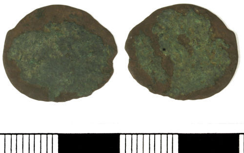
Probably a radiate copy of Tetricus I dating from c. AD271-274.
Created on: Wednesday 28th November 2007
Last updated: Thursday 24th February 2011
Spatial data recorded.
This findspot is known as 'Sleaford', grid reference and parish protected.

Record ID: LANCUM-473852
Object type: COIN
Broad period: ROMAN
County: Lancashire
Workflow stage: Published ![]()
Roman radiate of Tetricus I dating from AD271-274, HILARITAS AVGG. Ref. Cunetio p. 153, c.f. 2648
Created on: Wednesday 21st November 2007
Last updated: Thursday 24th February 2011
Spatial data recorded.
This findspot is known as 'Ribble Valley', grid reference and parish protected.
Records per page: 10 20 40 100
Sort your search by:
Which direction?
Total results available: 9
Search server index: asgard
You are viewing records: 1 - 9.
Search statistics
- Total quantity: 9
- Mean quantity: 1.000
- Maximum: 1
Filter your search
Object type
County of origin
Broad period
Institution
Ruler/issuer
Denomination
Mint
Material
Workflow
Reece Period
1 - 9 of 9 records.
About Us
About our Site

Find us
The British Museum, Great Russell Street, London WC1B 3DG.
T: +44(0) 20 73238618