
Back to simple search | Back to advanced search
- Complete:Complete
- Object type:COIN
- Denomination:uncertain
- County:Kent
- Primary material:Gold
- Show this many records per page:10
You searched for:
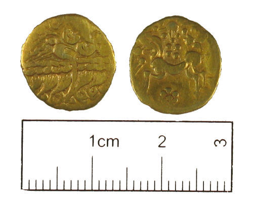
Record ID: KENT-70DD62
Object type: COIN
Broad period: IRON AGE
County: Kent
Workflow stage: Awaiting validation ![]()
An Iron Age gold Gallo-Belgic AB2 quarter-stater, Van Arsdell 20. Date is early to mid 2nd century BC.
Created on: Monday 3rd August 2009
Last updated: Thursday 3rd May 2012
Spatial data recorded.
-

Image not taken
Record ID: KENT-D5B428
Object type: COIN
Broad period: IRON AGE
County: Kent
Workflow stage: Awaiting validation ![]()
Iron Age stater. Dubnovellaunus.
Created on: Friday 30th September 2005
Last updated: Tuesday 1st March 2011
Spatial data recorded.
This findspot is known as 'Cobham', grid reference and parish protected.
-
Image not taken
Record ID: KENT1914
Object type: COIN
Broad period: IRON AGE
County: Kent
Workflow stage: Published ![]()
Created on: Friday 18th February 2000
Last updated: Thursday 24th February 2011
Spatial data recorded.
This findspot is known as 'KENT WORTH', grid reference and parish protected.
-
Image not taken
Record ID: KENT1871
Object type: COIN
Broad period: IRON AGE
County: Kent
Workflow stage: Published ![]()
Created on: Thursday 20th January 2000
Last updated: Thursday 24th February 2011
Spatial data recorded.
This findspot is known as 'KENT MINSTER', grid reference and parish protected.
-
Image not taken
Record ID: KENT227
Object type: COIN
Broad period: IRON AGE
County: Kent
Workflow stage: Published ![]()
Created on: Monday 27th July 1998
Last updated: Thursday 24th February 2011
Spatial data recorded.
This findspot is known as 'KENT FOLKESTONE', grid reference and parish protected.
-
Image not taken
Record ID: KENT164
Object type: COIN
Broad period: IRON AGE
County: Kent
Workflow stage: Published ![]()
Created on: Monday 20th July 1998
Last updated: Thursday 24th February 2011
Spatial data recorded.
This findspot is known as 'KENT CRUNDALE', grid reference and parish protected.
Records per page: 10 20 40 100
Sort your search by:
Which direction?
Total results available: 6
Search server index: objects
You are viewing records: 1 - 6.
Search statistics
- Total quantity: 6
- Mean quantity: 1.000
- Maximum: 1
Filter your search
Object type
County of origin
Broad period
Institution
Ruler/issuer
Denomination
Material
Workflow
1 - 6 of 6 records.
About Us
About our Site

Find us
The British Museum, Great Russell Street, London WC1B 3DG.
T: +44(0) 20 73238618