
Back to simple search | Back to advanced search
- Complete:Complete
- Primary material:Flint
- Sort:workflow
- County:City of Peterborough
You searched for:

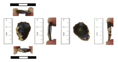
Record ID: CAM-01F395
Object type: THUMB NAIL SCRAPER
Broad period: NEOLITHIC
County: City of Peterborough
Workflow stage: Awaiting validation ![]()
A flint thumbnail scraper dating to the Later Neolithic or Early Bronze Age. The scraper is oval in shape with a coarsely retouched curved edge on the dorsal face. About a fifth of this edge is unworked - this is the butt area where the original flake was struck off the core. There is some yellowish white cortication in this area. The angle of retouch is about 45 degrees. The ventral surface has a pronounced bulb of percussion There is no retouch on the ventral surface. The scraper measures 28mm in length, 29mm in width and 11mm in thickness.
Created on: Wednesday 14th December 2005
Last updated: Thursday 13th October 2016
Spatial data recorded.
This findspot is known as 'Ufford', grid reference and parish protected.

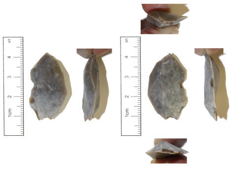
Record ID: PUBLIC-AFC4E2
Object type: LITHIC IMPLEMENT
Broad period: NEOLITHIC
County: City of Peterborough
Workflow stage: Awaiting validation ![]()
A flint blade, probably dating to the early Neolithic period (4000-3501BC) or possibly to the early Mesolithic (10,000-7001BC).
Flint - translucent mid grey to orange in colour.
The blade is rectangular in plan, with some cortex remaining on the distal end and covering about a third of its dorsal face.
The bulb of percussion and striking platform are clearly visible on the proximal end of the flake. The bulb of percussion shows the signs of a bulbar scar.
The artefact has been made out of a secondary flake.
The blade bears retouch on one edge to create serration. The po…
Created on: Friday 26th January 2018
Last updated: Tuesday 27th February 2018
Spatial data recorded.
Record ID: CAM-5435C3
Object type: FLAKE
Broad period: UNKNOWN
County: City of Peterborough
Workflow stage: Awaiting validation ![]()
A waste flake from flint working. A bulb of percussion and small amount of cortex is present. Length is 23.32mm, width is 17.74mm, thickness is 4.45mm and weight is 1.87g.
Created on: Friday 10th February 2012
Last updated: Friday 16th March 2012
Spatial data recorded.
This findspot is known as 'Maxey Area', grid reference and parish protected.

Record ID: CAM-5447C3
Object type: FLAKE
Broad period: UNKNOWN
County: City of Peterborough
Workflow stage: Awaiting validation ![]()
A worked flint core that might possibly have also been used, secondarily, as a scraper. A small area of cortex is present. Length is 29.92mm, width is 23.56mm, thickness is 12.19mm and weight is 8.95g.
Created on: Friday 10th February 2012
Last updated: Friday 16th March 2012
Spatial data recorded.
This findspot is known as 'Glinton Area', grid reference and parish protected.

Record ID: CAM-545537
Object type: FLAKE
Broad period: UNKNOWN
County: City of Peterborough
Workflow stage: Awaiting validation ![]()
A flint waste flake from flint working. The flake has small amounts of cortex present and a bulb of percussion. The flake has a impurities running through it including a particularly large one. Length is 29.48mm, width is 19.50mm, thickness is 6.47mm and weight is 3.49g.
Created on: Friday 10th February 2012
Last updated: Friday 16th March 2012
Spatial data recorded.
This findspot is known as 'Barnack Area', grid reference and parish protected.
Record ID: CAM-546033
Object type: FLAKE
Broad period: UNKNOWN
County: City of Peterborough
Workflow stage: Awaiting validation ![]()
A flint waste flake from flint working with a bulb of percussion present. The flake has a length of 34.68, width of 20.49mm, thickness of 7.68mm and weighs 4.34g.
Created on: Friday 10th February 2012
Last updated: Friday 16th March 2012
Spatial data recorded.
This findspot is known as 'Etton Area', grid reference and parish protected.

Record ID: CAM-546B21
Object type: FLAKE
Broad period: UNKNOWN
County: City of Peterborough
Workflow stage: Awaiting validation ![]()
A worked flint flake with some cortex present. This is probably a waste flake from flint working but might possibly have been or was intended to be a flint blade that now has an irregular transverse break travelling diagonally through the thickness of the flint . The fragment now has a roughtly squared shape with the length being only slightly longer than the width. The flake has a length of 19.93, width of 19.57mm, thickness of 5.87mm and weighs 2.96g.
Created on: Friday 10th February 2012
Last updated: Friday 16th March 2012
Spatial data recorded.
This findspot is known as 'Bainton Area', grid reference and parish protected.

Record ID: CAM-547503
Object type: FLAKE
Broad period: UNKNOWN
County: City of Peterborough
Workflow stage: Awaiting validation ![]()
A flint flake, probably a waste flake from flint working. The flake has a length of 21.85mm, width of 12.03mm, thickness of 3.97mm and weighs 0.86g.
Created on: Friday 10th February 2012
Last updated: Friday 16th March 2012
Spatial data recorded.
This findspot is known as 'Ailsworth Area', grid reference and parish protected.
Record ID: CAM-964985
Object type: DEBITAGE
Broad period: UNKNOWN
County: City of Peterborough
Workflow stage: Awaiting validation ![]()
A small struck piece of flint. This flint is light grey in colour and has a flat platform (maximum measurement 7.65mm) at one end and a shallow 'S' shaped profile. It is uncertain whether this is a waste flake from flint knapping or has been hit by modern mechanical diggers during earth moving on the site. This flint weighs 1.56g, has a thickness of 5.63mm, length 17.76mm and maximum width of 17.38mm.
Created on: Friday 20th July 2012
Last updated: Friday 31st August 2012
Spatial data recorded.
This findspot is known as 'Orton Waterville', grid reference and parish protected.
Records per page: 10 20 40 100
Sort your search by:
Which direction?
Total results available: 9
Search server index: valhalla
You are viewing records: 1 - 9.
Search statistics
- Total quantity: 9
- Mean quantity: 1.000
- Maximum: 1
Filter your search
Object type
County of origin
Broad period
Institution
Material
Workflow
1 - 9 of 9 records.
About Us
About our Site

Find us
The British Museum, Great Russell Street, London WC1B 3DG.
T: +44(0) 20 73238618