
Back to simple search | Back to advanced search
- Complete:Complete
- County:County of Herefordshire
- Show this many records per page:40
- Broad period:IRON AGE
- Direction:desc
- Sort:updated
- Object type:COSMETIC MORTAR
- Institution:PUBLIC
You searched for:

Record ID: PUBLIC-FEA7E1
Object type: COSMETIC MORTAR
Broad period: IRON AGE
County: County of Herefordshire
Workflow stage: Awaiting validation ![]()
A cast copper alloy end-looped cosmetic mortar (also known as cosmetic grinder or woad grinder) of later Iron Age to early Roman date circa 100 BC - 200 AD. The cosmetic mortar in incomplete having eroded and corroded terminals which taper to blunt points. In plan it is broadly a pointed oval shape (elliptical) with distinct crescent shaped profile; in cross section it is U shaped. The end loop is lost through an old break it is cast in one piece with the rest of the mortar. On the upper edge of the mortar is the grinding area / surface that is elliptical (sub-oval) in plan. The grind…
Created on: Saturday 2nd April 2016
Last updated: Friday 12th January 2018
Spatial data recorded.
This findspot is known as 'Monnington', grid reference and parish protected.
Record ID: PUBLIC-7BC7A2
Object type: COSMETIC MORTAR
Broad period: IRON AGE
County: County of Herefordshire
Workflow stage: Awaiting validation ![]()
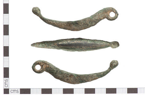
A copper-alloy end looped cosmetic mortar of Late Iron Age to Roman date. It has a triangular shaped bow, tapering towards its terminal end, that is V-shaped in section with a relatively deep central oval shaped groove on the interior surface. At one end is an integral oval loop with circular aperture and transverse notch along its underside where it joins the bow. The narrow terminal end has a single globular knop. The surface has a dark green patina with areas of bronze. It measures 79.6mm in length, 12.9mm in width, 22.2mm in height, 9.9mm in thickness and approximately 3mm in de…
Created on: Wednesday 19th October 2016
Last updated: Friday 12th January 2018
Spatial data recorded.
This findspot is known as 'Leintwardine', grid reference and parish protected.
Records per page: 10 20 40 100
Sort your search by:
Which direction?
Total results available: 2
Search server index: valhalla
You are viewing records: 1 - 2.
Search statistics
- Total quantity: 2
- Mean quantity: 1.000
- Maximum: 1
Filter your search
Object type
County of origin
Broad period
Institution
Material
Workflow
1 - 2 of 2 records.
About Us
About our Site

Find us
The British Museum, Great Russell Street, London WC1B 3DG.
T: +44(0) 20 73238618