
Back to simple search | Back to advanced search
- Broad period:MESOLITHIC
- Created by:Angie Bolton
- Object type:LITHIC IMPLEMENT
You searched for:
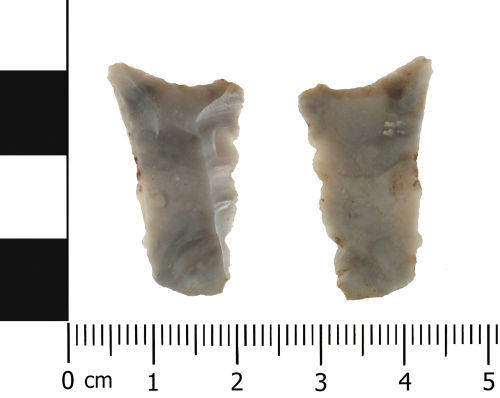
Record ID: WAW-2C9732
Object type: LITHIC IMPLEMENT
Broad period: MESOLITHIC
County: Worcestershire
Workflow stage: Awaiting validation ![]()
A Mesolithic lithic implement, possibly a multi-purpose tool due to dentriculates on one lateral edge and re-touch along the distal end. In plan the lithic is an elongated trapezoid with the narrow end forming the proximal end. This end is angular in profile and has feint transverse flakes. The distal end is asymmetrically concave in plan and has re-touch on the ventral face. Due to the asymmetrical nature of the distal end, one corner is slightly extended. This end has the elements of a burin. The dorsal surface has three linear vertical scars, and a fourth across the distal end. The …
Created on: Wednesday 6th February 2013
Last updated: Thursday 21st February 2013
Spatial data recorded.

Record ID: WAW-3C83D1
Object type: LITHIC IMPLEMENT
Broad period: MESOLITHIC
County: Worcestershire
Workflow stage: Awaiting validation ![]()
A flint secondary flake with the dorsal surfaces having three vertical slender negative flake scars. The flake weighs 1.31g.
The flake is possibly dated to the Mesolithic period.
Created on: Tuesday 13th July 2004
Last updated: Thursday 24th February 2011
Spatial data recorded.
Records per page: 10 20 40 100
Sort your search by:
Which direction?
Total results available: 2
Search server index: asgard
You are viewing records: 1 - 2.
Search statistics
- Total quantity: 2
- Mean quantity: 1.000
- Maximum: 1
Filter your search
Object type
County of origin
Broad period
Institution
Material
Workflow
1 - 2 of 2 records.
About Us
About our Site

Find us
The British Museum, Great Russell Street, London WC1B 3DG.
T: +44(0) 20 73238618