

Rights Holder: Birmingham Museums Trust
CC License: ![]()
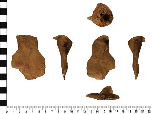
Image use policy
Our images can be used under a CC BY attribution licence (unless stated otherwise).
CASTING WASTE
Unique ID: WMID-0A0F8A
Object type certainty: Certain
Workflow
status: Awaiting validation ![]()
Two incomplete casting wells or jets of probable Roman and later dating (AD 43 to AD 1700).
Both casting wells are of a similar shape. They have an almost conical top tapering downwards into a flat sub rectangular section. This section is uneven with some area thicker than others. The top of each well is concave with an uneven surface.
The first well measures 79.2 mm in length, maximum width of 41.8 mm, maximum thickness of 27.5 mm and a minimum thickness of 2.8 mm. It weighs 139.6 g.
The second well measures 69.9 mm in length, 51.7 mm maximum width, maximum thickness of 30.3 mm and a minimum thickness of 2.5 mm. It weighs 143.8 g.
Together they both weigh 283.6 g.
Both wells are a dark brown colour, with an even surface patina. Surface XRF analysis has demonstrated that they are mostly Copper (Cu), but with traces of Tin (Sn), Lead (Pb), Iron (Fe) and Zinc (Zn).
Casting wells or jets can be hard to accurate date as the casting process stayed similar from the Bronze Age until Modern day. However the shape and XRF analysis is more consistent with a Roman or later date.
Class: well
Subsequent actions
Subsequent action after recording: Returned to finder
Chronology
Broad period: UNKNOWN
Period from: ROMAN
Period to: POST MEDIEVAL
Date from: Circa AD 43
Date to: Circa AD 1700
Dimensions and weight
Quantity: 2
Weight: 283.6 g
Personal details
This information is restricted for your access level.
Materials and construction
Primary material: Copper alloy
Manufacture method: Cast
Completeness: Incomplete
Spatial metadata
Region: West Midlands (European Region)County or Unitary authority: Walsall (Metropolitan District)
District: Walsall (Metropolitan District)
Parish or ward: Pheasey Park Farm (Metropolitan District Ward)
Spatial coordinates
4 Figure: SP0697
Four figure Latitude: 52.57079123
Four figure longitude: -1.91290517
1:25K map: SP0697
1:10K map: SP09NE
Unmasked grid reference accurate to a 1000 metre square.
References cited
No references cited so far.
Similar objects

Find number: WILT-E1CDD0
Object type: SPUR
Broadperiod: EARLY MEDIEVAL
An incomplete copper alloy Anglo-Scandinavian (AD c. 1050-1125) Urnes style prick spur. Overall, the spur measures 34.8mm long, 15.6mm wide a…
Workflow: Awaiting validation![]()

Find number: WMID-C9BDED
Object type: PALSTAVE
Broadperiod: BRONZE AGE
An incomplete copper alloy (bronze) copper-alloy Primary / Early phase Group III palstave of Middle Bronze Age dating (1500-1300 BC).
The …
Workflow: Awaiting validation![]()

Find number: SWYOR-3DAD49
Object type: FLANGED AXEHEAD
Broadperiod: BRONZE AGE
An incomplete developed flat axe with hammer raised flanges, of later Early Bronze Age dating (about 2000 BC to 1700 BC).
The axehead is b…
Workflow: Awaiting validation![]()
Timeline of associated dates
About Us
About our Site

Find us
The British Museum, Great Russell Street, London WC1B 3DG.
T: +44(0) 20 73238618