
Rights Holder: Birmingham Museums Trust
CC License: ![]()
Image use policy
Our images can be used under a CC BY attribution licence (unless stated otherwise).
BROOCH
Unique ID: WMID-969C40
Object type certainty: Certain
Workflow
status: Awaiting validation ![]()
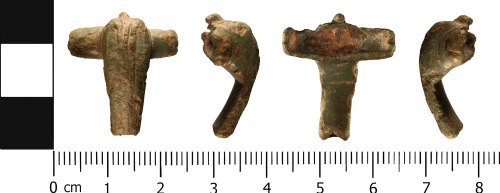
An incomplete copper alloy brooch of Colchester derivative, Polden Hill (Mackreth 2011, Part 3, Group 5, flat wing type, Western Group), c.f. Mackreth 2011, 5.b4.Plate 50, of Roman dating (AD 70 - AD 120).
Approximately 50% of the brooch is present consisting of an incomplete bow and wings. The foot, spring and pin are missing, presumed lost in antiquity.
In plan, the brooch is almost T-shaped, and D-shaped in cross section. The bow head is hump-like, and angular (comma shaped) in profile, with cylindrical wings projecting from either side at the top. The base of a rearward facing hook is situated at the head of the bow. The front of the bow has been decorated by two raised ridges. The foot is missing. Each of the wings has a sub circular flat wing cap, with a circular perforation for the spring axis bar. The ends of the wings are damaged, so decorative detail can not be determined. The back of the brooch is undecorated. A cylindrical groove is present along the length of the back, between the two wings. This would have originally held the spring.
The brooch measures 29.0 mm in length, 26.3 mm wide and 11.6 mm thick. It weighs 9.65 grams.
The brooch is a mid to dark green colour, and has an even surface patina.
A similar brooch has been recorded on the PAS database as WMID-4FEC52.
Class:
Colchester derivative, Polden Hill (Mackreth 2011, Part 3, Group 5, flat wing type, Western Group)
Sub class: Mackreth 2011, 5.b4.Plate 50
Subsequent actions
Subsequent action after recording: Returned to finder
Chronology
Broad period: ROMAN
Period from: ROMAN
Period to: ROMAN
Date from: Circa AD 70
Date to: Circa AD 120
Dimensions and weight
Quantity: 1
Length: 29 mm
Width: 26.3 mm
Thickness: 11.6 mm
Weight: 9.65 g
Discovery dates
Date(s) of discovery: Wednesday 20th February 2019 - Wednesday 20th February 2019
Personal details
This information is restricted for your access level.
Materials and construction
Spatial metadata
Region: West Midlands (European Region)County or Unitary authority: Staffordshire (County)
District: Stafford (District)
Parish or ward: Tixall (Civil Parish)
Spatial coordinates
4 Figure: SJ9823
Four figure Latitude: 52.80454957
Four figure longitude: -2.03110817
1:25K map: SJ9823
1:10K map: SJ92SE
Grid reference source: From finder
Unmasked grid reference accurate to a 1 metre square.
References cited
No references cited so far.
Similar objects

Find number: WMID-7F34A9
Object type: BROOCH
Broadperiod: ROMAN
An incomplete copper alloy brooch of Colchester derivative, Polden Hill (Mackreth 2011, Part 3, Group 5, flat wing type, Western Group), c.f.…
Workflow: Published![]()

Find number: WMID-AE646A
Object type: BROOCH
Broadperiod: ROMAN
An incomplete copper alloy brooch of Colchester derivative, Polden Hill (Mackreth 2011, Part 3, Group 5, flat wing type, Western Group), c.f.…
Workflow: Awaiting validation![]()

Find number: WMID-4FEC52
Object type: BROOCH
Broadperiod: ROMAN
An incomplete copper alloy brooch of Colchester derivative, Polden Hill (Mackreth 2011, Part 3, Group 5, flat wing type, Western Group), c.f.…
Workflow: Published![]()
Timeline of associated dates
About Us
About our Site

Find us
The British Museum, Great Russell Street, London WC1B 3DG.
T: +44(0) 20 73238618