
Rights Holder: Cambridgeshire County Council
CC License: ![]()
Image use policy
Our images can be used under a CC BY attribution licence (unless stated otherwise).
UNIDENTIFIED OBJECT
Unique ID: CAM-DAA925
Object type certainty: Certain
Workflow
status: Awaiting validation ![]()
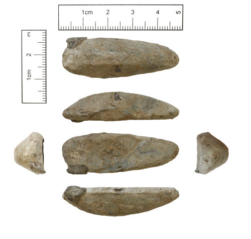
Lead from a casting well and gate weighing 49.5g. The well is keel shaped, with a convexly curved elongated asymmetric semi-circular length profile measuring 47.9mm. The well has a maximum width of 16.7mm which also has a convexly curved sub-semi-circular cross-section. The well has a maximum depth of 11.6mm. The top of the well is flat with a slight hint of concave depression. The well has an elliptical shape. At the wider end a protrusion of metal is likely to be the remains of a casting gate. This protrusion extends out from the side of the well by 3.0mm, has a width of 9.3mm, and maximum height of 6.6mm. Towards the centre of the flat surface, at this end of the well, the impression of a pair of pliers can be seen. The impressions consist of multiple parallel transverse grooves and ridges. The marks measure 9.3mm in from the end of the well and have a width of 7.4mm. The plier marks are present on the curved underside of the well but are much less distinct than those on the upper flat surface.
The date of this casting waste is uncertain.
Subsequent actions
Subsequent action after recording: Returned to finder
Chronology
Broad period: UNKNOWN
Period from: UNKNOWN
Period to: UNKNOWN
Dimensions and weight
Quantity: 1
Length: 47.9 mm
Width: 16.7 mm
Thickness: 11.6 mm
Weight: 49.5 g
Discovery dates
Date(s) of discovery: Wednesday 1st November 2017 - Sunday 31st December 2017
Personal details
This information is restricted for your access level.
Materials and construction
Spatial metadata
Region: Eastern (European Region)County or Unitary authority: Cambridgeshire (County)
District: East Cambridgeshire (District)
Parish or ward: Burwell (Civil Parish)
Spatial coordinates
4 Figure: TL5768
Four figure Latitude: 52.28771092
Four figure longitude: 0.30039588
1:25K map: TL5768
1:10K map: TL56NE
Grid reference source: From a paper map
Unmasked grid reference accurate to a 1 metre square.
References cited
No references cited so far.
Similar objects

Find number: CAM-096A0B
Object type: BUCKLE
Broadperiod: MEDIEVAL
A copper-alloy Medieval buckle with integral plate dating c. AD 1250-1400. This buckle weighs 5.68g. It has a length of 40.8mm, maximum width…
Workflow: Awaiting validation![]()

Find number: CAM-0EED86
Object type: BUCKLE
Broadperiod: POST MEDIEVAL
A Post-Medieval buckle frame dating to c. AD 1575-1700. This artefact weighs 1.37g, has a maximum length of 23.6mm, maximum width of 15.2mm an…
Workflow: Awaiting validation![]()

Find number: NMS-F00565
Object type: MOUNT
Broadperiod: POST MEDIEVAL
An incomplete copper-alloy hooked mount of probable 16th-17th century AD date (B. Read; 2001; pp. 30; no.355). It is suggested that the funct…
Workflow: Awaiting validation![]()
About Us
About our Site

Find us
The British Museum, Great Russell Street, London WC1B 3DG.
T: +44(0) 20 73238618