
Rights Holder: Colchester and Ipswich Museum Service
CC License: ![]()
Image use policy
Our images can be used under a CC BY attribution licence (unless stated otherwise).
LITHIC IMPLEMENT
Unique ID: ESS-1F6B9C
Object type certainty: Certain
Workflow
status: Awaiting validation ![]()
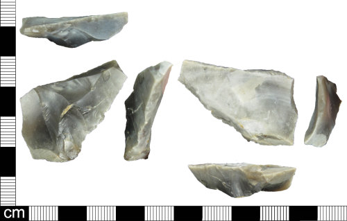
Partially worked flake of grey flint, likely dating to the late Neolithic/early Bronze Age, c. 3000 - 1500 BC.
There is retouch along the upper left edge when viewed from the ventral face which is scaled and thins the flake edge slightly. The right edge of the ventral face also shows evidence of retouch, along the bottom edge forming a shallow crescent. The upper right edge of the ventral face is straight and diagonal. When viewed from the dorsal face this edge is backed almost all along its length, with only a small portion in the middle showing no evidence of retouch.
The retouch along the straight edge on the dorsal face is steep and takes the form of small parallel removals.
There are also removals along the right edge of the dorsal face, with small scale retouch centred on a protrusions which is an extension of the striking platform. There are also some more invasive removals toward the distal end of the flake on the dorsal face.
Dimensions: weight: 10.1g, length: 38.9mm, width: 39.4mm, thickness: 10.8mm
Class: Flake
Subsequent actions
Subsequent action after recording: Returned to finder
Chronology
Broad period: BRONZE AGE
Period from: BRONZE AGE
Period to: BRONZE AGE
Date from: Circa 3000 BC
Date to: Circa 1500 BC
Dimensions and weight
Quantity: 1
Length: 38.9 mm
Width: 39.4 mm
Thickness: 10.8 mm
Weight: 10.1 g
Personal details
This information is restricted for your access level.
Materials and construction
Primary material: Flint
Manufacture method: Knapped/flaked
Completeness: Complete
Spatial metadata
Region: Eastern (European Region)County or Unitary authority: Essex (County)
District: Colchester (District)
Parish or ward: East Mersea (Civil Parish)
Spatial coordinates
4 Figure: TQ0614
Four figure Latitude: 50.91573914
Four figure longitude: -0.49348373
1:25K map: TQ0614
1:10K map: TQ01SE
Grid reference source: From finder
Unmasked grid reference accurate to a 1 metre square.
References cited
No references cited so far.
Similar objects

Find number: ESS-A38F0D
Object type: ASSEMBLAGE
Broadperiod: MESOLITHIC
An assemblage of lithic artefacts found within an approximate 0.25km2 area. Many of the flints appear to be similar in form, colour and manuf…
Workflow: Awaiting validation![]()

Find number: SOM-678477
Object type: SCRAPER (TOOL)
Broadperiod: BRONZE AGE
A flint scraper of Prehsitoric date and possibly from the Bronze Age c. 2400-800 BC.
The scraper is worked from a large secondary flake fl…
Workflow: Awaiting validation![]()

Find number: ESS-46C877
Object type: LITHIC IMPLEMENT
Broadperiod: PALAEOLITHIC
A worked pointed lithic implement. The tool is a dark grey flint with lighter grey and beige coloured inclusions. The surface retouch and fla…
Workflow: Awaiting validation![]()
Timeline of associated dates
About Us
About our Site

Find us
The British Museum, Great Russell Street, London WC1B 3DG.
T: +44(0) 20 73238618