
Rights Holder: Hampshire Cultural Trust
CC License: ![]()
Image use policy
Our images can be used under a CC BY attribution licence (unless stated otherwise).
TOKEN
Unique ID: HAMP-1EBDD3
Object type certainty: Certain
Workflow
status: Awaiting validation ![]()
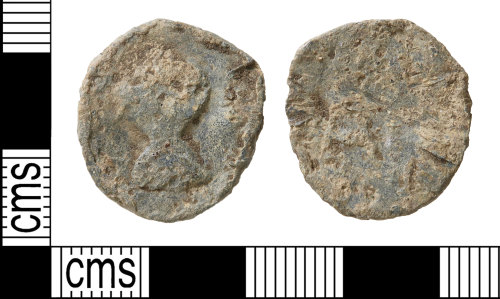
A post-medieval lead circular double-sided token, dating to c. 1500-1850.
The token has raised bust on one side within a raised edge; it is uncertain in which direction the bust is facing. The reverse has a raised letter A placed off-centre; it has no raised edge.
Lead tokens had a wide variety of potential uses such as tallies, gaming pieces, tickets, weights, etc. and are believed to have been locally produced; they are therefore difficult to date precisely. Those carrying initials are generally deemed to be post-medieval in date (1500-1850), those which seem to mimic medieval penny designs are deemed to be medieval, the remainder which carry stylised designs remain difficult to date but the majority are probably post-medieval in date c. 1500-1850.
Subsequent actions
Subsequent action after recording: Returned to finder
Chronology
Broad period: POST MEDIEVAL
Period from: POST MEDIEVAL
Period to: POST MEDIEVAL
Date from: Circa AD 1500
Date to: Circa AD 1850
Dimensions and weight
Quantity: 1
Weight: 6.53 g
Diameter: 20.9 mm
Discovery dates
Date(s) of discovery: Sunday 17th December 2017 - Sunday 17th December 2017
Personal details
This information is restricted for your access level.
Other reference numbers
Other reference: Hampshire Cultural Trust Object Entry Form WINCM 637
Materials and construction
Primary material: Lead
Completeness: Complete
Jetton / token data
Class: Other
Group: Other
Type: Other
Denomination: Token penny
Obverse description: Raised bust within raised edge (it is uncertain in which direction the bust is facing).
Reverse description: Raised A placed off-centre; no raised edge.
Die axis measurement: 12 o'clock
Spatial metadata
Region: South East (European Region)County or Unitary authority: Oxfordshire (County)
District: Vale of White Horse (District)
Parish or ward: Cumnor (Civil Parish)
Spatial coordinates
4 Figure: SP4605
Four figure Latitude: 51.7418227
Four figure longitude: -1.33518263
1:25K map: SP4605
1:10K map: SP40NE
Grid reference source: Generated from computer mapping software
Unmasked grid reference accurate to a 10 metre square.
References cited
No references cited so far.
Similar objects

Find number: IOW-87ED44
Object type: TOKEN
Broadperiod: POST MEDIEVAL
An incomplete post-Medieval cast lead or lead alloy circular double-sided token (c. 1500-c. 1850). Powell Type 2/27.
The token has raised …
Workflow: Awaiting validation![]()

Find number: IOW-2945BC
Object type: TOKEN
Broadperiod: POST MEDIEVAL
An incomplete post-Medieval cast lead or lead alloy circular double-sided token (c. 1500-c. 1850). Powell Type 2/3.
The token has a raised…
Workflow: Awaiting validation![]()

Find number: IOW-808F3F
Object type: TOKEN
Broadperiod: POST MEDIEVAL
A complete post-Medieval cast lead or lead alloy circular double-sided token (c. 1500-c. 1850). Powell Type 2/5.
The token has raised init…
Workflow: Awaiting validation![]()
Timeline of associated dates
About Us
About our Site

Find us
The British Museum, Great Russell Street, London WC1B 3DG.
T: +44(0) 20 73238618