
Rights Holder: The Portable Antiquities Scheme
CC License: ![]()
Image use policy
Our images can be used under a CC BY attribution licence (unless stated otherwise).
CORE
Unique ID: DOR-3465C3
Object type certainty: Certain
Workflow
status: Awaiting validation ![]()
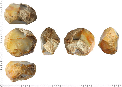
A re-utilised flint core, re-used as a hammerstone. Originally a core comprising of at least six large to medium sized flakes taken from two platforms from a naturally fractured nodule fragment of flint with thick chalky cortex surviving at one end and part of one side. The core has been re-utilised as a hammerstone; evidence of this can be seen in an area of well developed characteristic impact chatter and abrasion running around almost half of the circumference. An area of cortex appears to been utilised for grip and is unaffected. The object has high-gloss surfaces where flint is exposed, and grades from almost unpatinated at one end to pale yellow and orange opaque stain at the other.
Date: Late Neolithic to Early Bronze Age: 300 to 1600BC
Dimensions: 77mm x 68.4mm x 46.3mm.
Weight: 311g.
Evidence of reuse: Characteristic impact chatter and hammerstone abrasions around part of the central belt.
Subsequent actions
Subsequent action after recording: Returned to finder
Chronology
Broad period: NEOLITHIC
Subperiod from: Late
Period from: NEOLITHIC
Subperiod to: Early
Period to: BRONZE AGE
Date from: Circa 3300 BC
Date to: Circa 1600 BC
Dimensions and weight
Quantity: 1
Length: 77 mm
Width: 68.4 mm
Thickness: 46.3 mm
Weight: 311 g
Discovery dates
Date(s) of discovery: Thursday 1st June 2017 - Friday 30th June 2017
Personal details
This information is restricted for your access level.
Other reference numbers
Other reference: SCMS-019037/3
Materials and construction
Primary material: Flint
Manufacture method: Knapped/flaked
Completeness: Complete
Spatial metadata
Region: South West (European Region)County or Unitary authority: Dorset (County)
District: North Dorset (District)
Parish or ward: Tarrant Crawford (Civil Parish)
Spatial coordinates
4 Figure: ST9303
Four figure Latitude: 50.82649449
Four figure longitude: -2.10075328
1:25K map: ST9303
1:10K map: ST90SW
Grid reference source: From finder
Unmasked grid reference accurate to a 1 metre square.
References cited
No references cited so far.
Similar objects

Find number: DOR-D2D2E5
Object type: HANDAXE
Broadperiod: PALAEOLITHIC
A thick-butted handaxe made on a weathered secondary nodule of mid to dark grey flint, visible on a small area of modern damage on the tip. S…
Workflow: Awaiting validation![]()

Find number: DOR-D2B9CE
Object type: FLAKED AXEHEAD
Broadperiod: NEOLITHIC
A possible flaked axehead made on a small, tapering secondary nodule of mottled semi-translucent mid to dark grey flint with high-gloss patin…
Workflow: Awaiting validation![]()
Find number: SF8021
Object type: CORE
Broadperiod: MESOLITHIC
Single-platform flake core of gravel flint. Cortex on concave surface. Black flint, patinated pale blue/grey. Unpatinated re-utilisation (o…
Workflow: Published![]()
Timeline of associated dates
About Us
About our Site

Find us
The British Museum, Great Russell Street, London WC1B 3DG.
T: +44(0) 20 73238618