
Rights Holder: Somerset County Council
CC License: ![]()
Image use policy
Our images can be used under a CC BY attribution licence (unless stated otherwise).
SCRAPER (TOOL)
Unique ID: SOM-3B6A7D
Object type certainty: Certain
Workflow
status: Awaiting validation ![]()
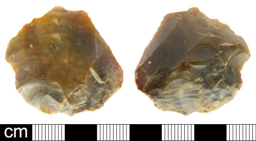
A knapped flint scraper of probable Bronze Age date (c.2350-800 BC). The piece is struck off a tertiary flake with no cortex remaining. The general form is very irregularly circular with a flake broader than it is long. The dorsal surface and sides exhibit multiple negative flake scars from previous removals from several different directions indicating a multi-platform core. The bulb of percussion on the ventral face has been almost removed by bulb scar but there are strong percussion ripples. There is scalar to sub-parallel, semi abrupt invasive retouch, becoming shallow towards the centre of the flint, running across the proximal half of the dorsal face. There is also sub-parallel semi-abrupt long retouch at the distal end on the dorsal face. The flint is high quality translucent dark brown with mid brown opaque mottling.
It is 33.6mm in length with a maximum width of 36.8mm, it is 11.6mm thick, with a weight of 14.30g
Subsequent actions
Subsequent action after recording: Returned to finder
Chronology
Broad period: BRONZE AGE
Period from: BRONZE AGE
Period to: BRONZE AGE
Date from: Circa 2350 BC
Date to: Circa 800 BC
Dimensions and weight
Quantity: 1
Length: 33.6 mm
Width: 36.8 mm
Thickness: 11.6 mm
Weight: 14.3 g
Discovery dates
Date(s) of discovery: Friday 1st July 2016 - Saturday 10th September 2016
Personal details
This information is restricted for your access level.
Other reference numbers
Other reference: SCC receipt 17444
Materials and construction
Primary material: Flint
Manufacture method: Knapped/flaked
Completeness: Complete
Spatial metadata
Region: South West (European Region)County or Unitary authority: Somerset (County)
District: South Somerset (District)
Parish or ward: South Petherton (Civil Parish)
Spatial coordinates
4 Figure: ST4418
Four figure Latitude: 50.95869154
Four figure longitude: -2.79871333
1:25K map: ST4418
1:10K map: ST41NW
Grid reference source: From a paper map
Unmasked grid reference accurate to a 100 metre square.
References cited
No references cited so far.
Similar objects

Find number: SOM-3BA068
Object type: DEBITAGE
Broadperiod: BRONZE AGE
Two knapped flint flakes with small areas of retouch. The crude thick flakes, broader than they are long, suggest a Bronze Age date, 2350-…
Workflow: Awaiting validation![]()

Find number: SOM-B624A7
Object type: RETOUCHED FLAKE
Broadperiod: BRONZE AGE
A knapped flint retouched flake, possibly a side and end scraper of probable Bronze Age date (c. 2350-800 BC). The piece is struck off a se…
Workflow: Awaiting validation![]()

Find number: SOM-CABC4C
Object type: SCRAPER (TOOL)
Broadperiod: NEOLITHIC
Five Neolithic to Early Bronze Age flint scrapers, probably dating to c. 4000-1,500BC.
A flint scraper worked from a secondary or tertiar…
Workflow: Awaiting validation![]()
Timeline of associated dates
About Us
About our Site

Find us
The British Museum, Great Russell Street, London WC1B 3DG.
T: +44(0) 20 73238618