
Rights Holder: West Yorkshire Archaeology Advisory Service
CC License: ![]()
Image use policy
Our images can be used under a CC BY attribution licence (unless stated otherwise).
TRANSVERSE ARROWHEAD
Unique ID: SWYOR-EE6ED7
Object type certainty: Possibly
Workflow
status: Awaiting validation ![]()
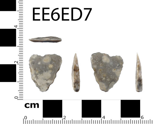
Flint possible transverse arrowhead of Late Neolithic date (3300 BC - 2200 BC). The flint is a mottled grey coloured, opaque, tertiary flake. It is sub-triangular in plan and sub-trapezoid in section. There is short, sub-parallel, abrupt, soft hammer retouch on both sides of the flint, carried out from the dorsal face. There is similar retouch to the distal end which has formed a small notch. It is 21mm long x 18mm wide x 3.5mm thick. Weight 1.3g.
Subsequent actions
Subsequent action after recording: Returned to finder
Chronology
Broad period: NEOLITHIC
Subperiod from: Late
Period from: NEOLITHIC
Subperiod to: Late
Period to: NEOLITHIC
Date from: Circa 3300 BC
Date to: Exactly 2200 BC
Dimensions and weight
Quantity: 1
Length: 21 mm
Width: 18 mm
Thickness: 3.5 mm
Weight: 1.3 g
Discovery dates
Date(s) of discovery: Monday 16th November 2015 - Monday 16th November 2015
Personal details
This information is restricted for your access level.
Other reference numbers
Other reference: PAS Form No 002783
Materials and construction
Primary material: Flint
Manufacture method: Knapped/flaked
Completeness: Incomplete
Spatial metadata
Region: Yorkshire and the Humber (European Region)County or Unitary authority: Calderdale (Metropolitan District)
District: Calderdale (Metropolitan District)
Parish or ward: Ripponden (Civil Parish)
Spatial coordinates
4 Figure: SE0418
Four figure Latitude: 53.65847651
Four figure longitude: -1.94094904
1:25K map: SE0418
1:10K map: SE01NW
Grid reference source: GPS (from the finder)
Unmasked grid reference accurate to a 1 metre square.
References cited
No references cited so far.
Similar objects

Find number: SWYOR-50FC4A
Object type: SCRAPER (TOOL)
Broadperiod: MESOLITHIC
Flint end scraper of broad Mesolithic/Neolithic date (9000 - 2200 BC). The flint is a mottled light grey coloured, opaque, tertiary flake. It…
Workflow: Awaiting validation![]()

Find number: SWYOR-4ECB8E
Object type: RETOUCHED FLAKE
Broadperiod: MESOLITHIC
Flint retouched blade of broad Mesolithic/Neolithic date (9000 - 2200 BC). The flint is a mottled light grey coloured, opaque, tertiary flake…
Workflow: Awaiting validation![]()

Find number: SWYOR-511AB1
Object type: SCRAPER (TOOL)
Broadperiod: MESOLITHIC
Flint end scraper of broad Mesolithic/Neolithic date (9000 - 2200 BC). The flint is a mottled light grey coloured, opaque, tertiary flake. It…
Workflow: Awaiting validation![]()
Timeline of associated dates
About Us
About our Site

Find us
The British Museum, Great Russell Street, London WC1B 3DG.
T: +44(0) 20 73238618