
Rights Holder: Bristol City Council
CC License: ![]()
Image use policy
Our images can be used under a CC BY attribution licence (unless stated otherwise).
BROOCH
Unique ID: GLO-B61A17
Object type certainty: Certain
Workflow
status: Published ![]()
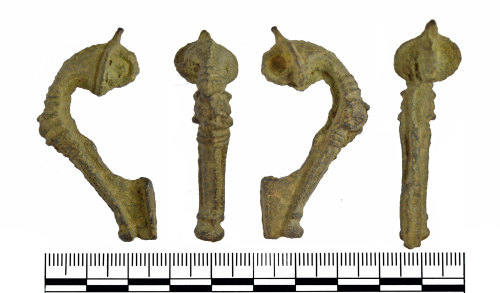
Roman copper alloy trumpet brooch that has an undecorated sub-oval head plate with a loop on the reverse for the spring and pin (now missing). At the apex of the bow is a moulded triple knop that is in between two triple sets of flanged ridges. The lower half of the bow has a raised border down each edge that terminates at the rounded footknob, which consists of a transvers moulding above a waist and then a globular knob. On the reverse the catch plate is complete, and turns to the left when viewed from behind. Date 75-175AD.
This brooch appears to be unfinished or not cleaned after casting, as it still retains a large casting flash around the whole of the artefact, visible on the reverse of the bow. Furthermore the metal also fills in the loop at the back of the head, which means that a pin was never mounted on this item. It is alternatively possible that the loop is filled with corrosion, as the catchplate is turned over which presumably was normally done during post-casting finishing.
Class: trumpet
Subsequent actions
Subsequent action after recording: Returned to finder
Chronology
Broad period: ROMAN
Period from: ROMAN
Period to: ROMAN
Date from: Circa AD 75
Date to: Circa AD 175
Dimensions and weight
Quantity: 1
Length: 50 mm
Width: 24 mm
Thickness: 15 mm
Weight: 17.16 g
Discovery dates
Date(s) of discovery: Monday 1st December 2014 - Sunday 1st March 2015
Personal details
This information is restricted for your access level.
Materials and construction
Spatial metadata
Region: South West (European Region)County or Unitary authority: South Gloucestershire (Unitary Authority)
District: South Gloucestershire (Unitary Authority)
Parish or ward: Falfield (Civil Parish)
Spatial coordinates
4 Figure: ST6691
Four figure Latitude: 51.61679094
Four figure longitude: -2.49246309
1:25K map: ST6691
1:10K map: ST69SE
Grid reference source: From finder
Unmasked grid reference accurate to a 1 metre square.
References cited
No references cited so far.
Similar objects

Find number: GLO-04FD03
Object type: BROOCH
Broadperiod: ROMAN
Roman copper alloy trumpet brooch that has an oval head plate that is surmounted by a truncated loop. on the reverse are two rearward facing …
Workflow: Awaiting validation![]()

Find number: GLO-E89C0C
Object type: BROOCH
Broadperiod: ROMAN
Roman copper alloy trumpet brooch that has a semi-circular head plate that is surmounted by a loop. On the reverse is a transverse cylinder t…
Workflow: Awaiting validation![]()

Find number: SWYOR-546274
Object type: BROOCH
Broadperiod: ROMAN
An incomplete copper alloy Roman trumpet brooch dating from about 75 - 175 AD. The brooch may have been discarded unfinished. The central sea…
Workflow: Awaiting validation![]()
Timeline of associated dates
About Us
About our Site

Find us
The British Museum, Great Russell Street, London WC1B 3DG.
T: +44(0) 20 73238618