
Rights Holder: Birmingham Museums Trust
CC License: ![]()
Image use policy
Our images can be used under a CC BY attribution licence (unless stated otherwise).
BROOCH
Unique ID: WMID-4BDA1C
Object type certainty: Certain
Workflow
status: Published ![]()
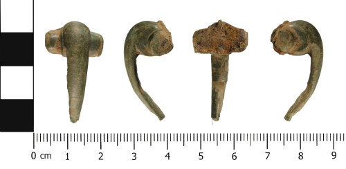
An incomplete copper alloy brooch of Colchester derivative Polden Hill (Mackreth Group 4, flat wing ends type, West Midlands), Mackreth 2011, 4.b. Plate 46, of Roman date (AD 80 to AD 120).
Approximately 70% of the brooch is present, consisting of the head, bow, both wings and spring. The foot, catchplate and pin are missing, presumably lost in antiquity.
In plan, the brooch is almost T-shaped, and D-shaped in cross section. The bow head is hump-like, and angular (comma shaped) in profile, with cylindral wings projecting from either side at the top. The remains of a rear ward facing hook is present at the head of the bow, this would held part of the spring (now missing). No decoration is present on the front of the bow or the wings, however where the wings meet the bow there is a semi circular ridges. Each of the wings has a sub circular pierced wing cap.The back of the brooch is undecorated. A cylindrical groove is present behind the wings, this holdsthe spring (made of iron, heavily corroded). Remains of the catchplate are present at the base of the brooch.
The brooch measures 34.7 mm in length and is 18.9 mm wide. It has a thickness of 11.5 mm and weighs 9.4 g.
The brooch is a mid green colour, with an even patina. Abrasion, caused by movement whilst within the plough soil, has resulted in a loss of some of the original surface detail.
Class:
Colchester derivative Polden Hill (Mackreth Group 4, flat wing ends type, West Midlands)
Sub class: Mackreth 2011, 4.b. Plate 46
Subsequent actions
Subsequent action after recording: Returned to finder
Chronology
Broad period: ROMAN
Period from: ROMAN
Period to: ROMAN
Date from: Circa AD 80
Date to: Circa AD 120
Dimensions and weight
Quantity: 1
Length: 34.7 mm
Width: 18.9 mm
Thickness: 11.5 mm
Weight: 9.4 g
Discovery dates
Date(s) of discovery: Wednesday 13th August 2014 - Wednesday 13th August 2014
Personal details
This information is restricted for your access level.
Materials and construction
Spatial metadata
Region: West Midlands (European Region)County or Unitary authority: Staffordshire (County)
District: South Staffordshire (District)
Parish or ward: Essington (Civil Parish)
Spatial coordinates
4 Figure: SJ9502
Four figure Latitude: 52.6157479
Four figure longitude: -2.07528184
1:25K map: SJ9502
1:10K map: SJ90SE
Grid reference source: From finder
Unmasked grid reference accurate to a 100 metre square.
References cited
No references cited so far.
Similar objects

Find number: WMID-4CBCB6
Object type: BROOCH
Broadperiod: ROMAN
An incomplete copper alloy brooch of Colchester derivative, Polden Hill (Mackreth Group 4, flat wing ends type, West Midlands), Mackreth 2011…
Workflow: Published![]()

Find number: PUBLIC-650D27
Object type: BROOCH
Broadperiod: ROMAN
A near complete cast copper alloy Roman brooch of Colchester derivative Polden Hill (flat wing ends type, West Midlands, Mackreth 2011, 4.a-b…
Workflow: Published![]()

Find number: WMID-CCC70B
Object type: BROOCH
Broadperiod: ROMAN
An incomplete copper alloy Colchester derivative Polden Hill (Mackreth Group 4, flat wing ends type, West Midlands), Mackreth 2011, 4.i2. Pla…
Workflow: Published![]()
Timeline of associated dates
About Us
About our Site

Find us
The British Museum, Great Russell Street, London WC1B 3DG.
T: +44(0) 20 73238618