

Rights Holder: Cambridgeshire County Council
CC License: ![]()
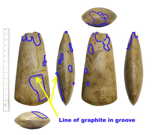
Image use policy
Our images can be used under a CC BY attribution licence (unless stated otherwise).
AXEHEAD
Unique ID: CAM-5EAB98
Object type certainty: Certain
Workflow
status: Published ![]()
An Early to Middle Neolithic polished stone axehead dating c. 4000-3300 BC.
This axehead has a pointed-oval cross section. One side edge has a slight flattened lateral facet, the opposing side edge having a subtler flattened lateral facet that could easily be missed during a very quick examination of this artefact thus giving the impression of a lateral rounded-pointed edge. The artefact weighs 290.74g, has a length of 126.5mm, maximum width of 60.5mm and maximum thickness of 31.7mm. The type of stone used to create this axehead has not yet been fully identified however the finder has been advised to request an appointment at the Sedgwick Museum of Earth Sciences, Downing Street, Cambridge in order to seek the expertise of a Geologist there. Mr Steve Critchley, Geologist, thinks that it might possibly be some sort of silicified volcanic ash, however this is not a Langdale axe, and that proper examination is required. There are some areas of damage of varing size. These areas of damage are indicated on the annotated image attached to this record. The largest area of damage ends in an abrupt narrow ledge, the inner junction of which currently contains a layer of graphite presumed to be present due to a pencil nib having been moved backwards and forwards within this feature of the axe. It was possible to remove a little of this graphite with an eraser however some remains.
See PAS record CAM-BAD957.
Subsequent actions
Subsequent action after recording: Returned to finder
Chronology
Broad period: NEOLITHIC
Subperiod from: Early
Period from: NEOLITHIC
Subperiod to: Middle
Period to: NEOLITHIC
Date from: Circa 4000 BC
Date to: Circa 3300 BC
Dimensions and weight
Quantity: 1
Length: 126.5 mm
Width: 60.5 mm
Thickness: 31.7 mm
Weight: 290.74 g
Discovery dates
Date(s) of discovery: Tuesday 1st January 1980 - Wednesday 31st December 1980
Personal details
This information is restricted for your access level.
Materials and construction
Primary material: Stone
Manufacture method: Ground/polished
Completeness: Complete
Spatial metadata
Region: Eastern (European Region)County or Unitary authority: City of Peterborough (Unitary Authority)
District: City of Peterborough (Unitary Authority)
Parish or ward: Maxey (Civil Parish)
Spatial coordinates
4 Figure: TF1307
Four figure Latitude: 52.64897266
Four figure longitude: -0.33114399
1:25K map: TF1307
1:10K map: TF10NW
Grid reference source: From a paper map
Unmasked grid reference accurate to a 10 metre square.
References cited
No references cited so far.
Similar objects

Find number: HESH-535862
Object type: AXEHEAD
Broadperiod: NEOLITHIC
Possible polished axe-head or model of an axe-head of later Neolithic (2900-2100 BC). There is a great amount of debate in the identification…
Workflow: Awaiting validation![]()

Find number: HESH-3BACA6
Object type: AXEHEAD
Broadperiod: NEOLITHIC
A complete but damaged knapped, ground and polished axe head of probable later Neolithic date (2900-2100 BC). The axe is knapped from a mid g…
Workflow: Published![]()

Find number: HESH-C57A28
Object type: AXEHEAD
Broadperiod: NEOLITHIC
A complete, but damaged, knapped, ground and polished flint axehead of probable later Neolithic date (2900-2100 BC). The axe is knapped from …
Workflow: Awaiting validation![]()
Timeline of associated dates
About Us
About our Site

Find us
The British Museum, Great Russell Street, London WC1B 3DG.
T: +44(0) 20 73238618