
Rights Holder: All rights reserved
CC License: ![]()
Image use policy
Our images can be used under a CC BY attribution licence (unless stated otherwise).
BROOCH
Unique ID: NMGW-8E1549
Object type certainty: Certain
Workflow
status: Published ![]()
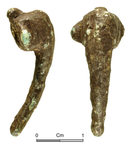
Roman copper alloy bow brooch of Colchester derivative, Polden Hill (Mackreth 2011, Part 3, Group 4, flat wing cap type), c.f. Mackreth 2011, 4.l, Plate 48. and of 1st to 2nd century AD date.
The brooch is fragmentary missing the leg and wings (with a surviving length of 29.0mm, a surviving depth of 10.9mm and a weight of 3.8g). The brooch employed a spring mechanism, now missing, probably behind wings with perforated terminals, now lost (with a surviving width of 11.9mm). Above the head is the remnant of a hook to tension the chord. The head has curved mouldings on the sides (giving a width of 8.5mm). Much of the decorative detail on the brooch has been lost; there is the suggestion of a midrib running along the bow, now heavily worn and corroded. The bow is of D-shaped section, with straight sides gradually converging to the break. A slight rib on the rear of the bow, above the break suggests the start of the catch-plate. The surface has a dark-brown patina with areas of bright green corrosion.
Class:
Colchester derivative, Polden Hill (Mackreth 2011, Part 3, Group 4, flat wing cap type)
Sub class: Mackreth 2011, 4.l, Plate 48
Subsequent actions
Subsequent action after recording: Returned to finder
Chronology
Broad period: ROMAN
Period from: ROMAN
Period to: ROMAN
Date from: Circa AD 80
Date to: Circa AD 160
Dimensions and weight
Quantity: 1
Length: 29 mm
Width: 11.9 mm
Weight: 3.8 g
Personal details
This information is restricted for your access level.
Other reference numbers
Other reference: NMWPA 2013.81
Materials and construction
Spatial metadata
Region: Wales (European Region)County or Unitary authority: the Vale of Glamorgan (Unitary Authority)
District: the Vale of Glamorgan (Unitary Authority)
Parish or ward: Penllyn (Community)
Spatial coordinates
4 Figure: SS9677
Four figure Latitude: 51.48236087
Four figure longitude: -3.49909165
1:25K map: SS9677
1:10K map: SS97NE
Grid reference source: From finder
Unmasked grid reference accurate to a 10 metre square.
References cited
No references cited so far.
Similar objects

Find number: NMGW-3C8382
Object type: BROOCH
Broadperiod: ROMAN
The brooch is fragmentary, missing the leg and pin (with a surviving length of 18.6mm, a surviving depth of 9.4mm and a weight of 3.6g). The …
Workflow: Awaiting validation![]()

Find number: NMGW-73614B
Object type: BROOCH
Broadperiod: ROMAN
Roman copper alloy brooch of Colchester derivative, Polden Hill type (Mackreth 2011, Part 3, Group 5, flat wing ends type, Western Group), c.…
Workflow: Published![]()

Find number: NMGW-8D945B
Object type: BROOCH
Broadperiod: ROMAN
Roman copper alloy brooch of Colchester derivative, Polden Hill (Mackreth 2011, Part 3, Group 4.a-b., flat wing ends type), and of 1st centur…
Workflow: Published![]()
Timeline of associated dates
About Us
About our Site

Find us
The British Museum, Great Russell Street, London WC1B 3DG.
T: +44(0) 20 73238618