
Rights Holder: West Yorkshire Archaeology Advisory Service
CC License: ![]()
Image use policy
Our images can be used under a CC BY attribution licence (unless stated otherwise).
HOOKED TAG
Unique ID: SWYOR-777121
Object type certainty: Certain
Workflow
status: Awaiting validation ![]()
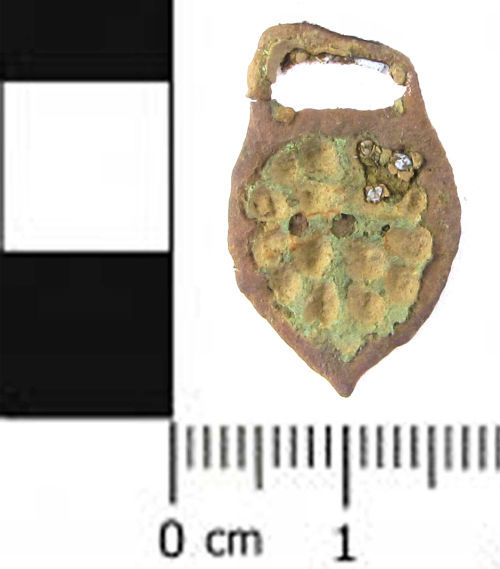
An incomplete, cast copper alloy, openwork hooked tag dating from the early post-Medieval period, AD 1500 - 1650. The body of the tag is sub-circular, with convex sides tapering to a point at the base and a flat top. The openwork design on the body consists of a plain cross with four circular perforations in each angle. Most of the design, except for two of the circular perforations, has been filled in by corrosion products. There is a rectangular attachment loop, now broken, projecting from the top. The curved hook that would have depended from the pointed base has broken away and is missing. The tag is 23.3mm long, 14.6mm wide and 1.5mm thick. It probably weighs a little less than 1.0gm (but since the fragile object is mounted onto paper with blue-tac, this weight has been calculated by weighing the tag with the paper, and then subtracting the weight of a piece of paper the same size, so the weight of the blue-tac may be exaggerating the true mass).
Similar tags are illustrated in Egan, 2005, Material Culture in London in an Age of Transition, page 44. A very similar example is YORYM-3CE514 which cites similar examples illustrated in Read, p.99 and classifies the hook as Read's Class E, Type 3.
Class: Read Class E type 3
Subsequent actions
Subsequent action after recording: Returned to finder
Chronology
Broad period: POST MEDIEVAL
Subperiod from: Late
Period from: POST MEDIEVAL
Period to: POST MEDIEVAL
Date from: Circa AD 1500
Date to: Circa AD 1650
Dimensions and weight
Quantity: 1
Length: 23.3 mm
Width: 14.6 mm
Thickness: 1.5 mm
Weight: 1 g
Discovery dates
Date(s) of discovery: Friday 11th April 2014 - Friday 18th April 2014
Personal details
This information is restricted for your access level.
Other reference numbers
Other reference: PAS form number 2156
Materials and construction
Primary material: Copper alloy
Manufacture method: Cast
Completeness: Incomplete
Spatial metadata
Region: Yorkshire and the Humber (European Region)County or Unitary authority: Bradford (Metropolitan District)
District: Bradford (Metropolitan District)
Parish or ward: Addingham (Civil Parish)
Spatial coordinates
4 Figure: SE0849
Four figure Latitude: 53.93705751
Four figure longitude: -1.87962926
1:25K map: SE0849
1:10K map: SE04NE
Grid reference source: Generated from computer mapping software
Unmasked grid reference accurate to a 100 metre square.
References cited
No references cited so far.
Similar objects

Find number: SWYOR-9C7E78
Object type: HOOKED TAG
Broadperiod: POST MEDIEVAL
A complete, copper alloy hooked tag, Read class E, type 2, dating from the early post-medieval period, AD 1500 - 1650. It has a shield shaped…
Workflow: Awaiting validation![]()

Find number: SWYOR-DF4CD6
Object type: HOOKED TAG
Broadperiod: POST MEDIEVAL
A cast copper alloy, openwork, hooked tag dating from the post-Medieval period, about AD 1500 - 1600. The body is circular and carries a desi…
Workflow: Awaiting validation![]()
Find number: SOMDOR-334C81
Object type: HOOKED TAG
Broadperiod: EARLY MEDIEVAL
Copper alloy hooked tag. Triangular tag tapering to a small hook. The wide top of the triangular plate has three circular pierced holes. There…
Workflow: Awaiting validation![]()
Timeline of associated dates
About Us
About our Site

Find us
The British Museum, Great Russell Street, London WC1B 3DG.
T: +44(0) 20 73238618