
Rights Holder: Somerset County Council
CC License: ![]()
Image use policy
Our images can be used under a CC BY attribution licence (unless stated otherwise).
SCRAPER (TOOL)
Unique ID: SOM-8E41C5
Object type certainty: Certain
Workflow
status: Published ![]()
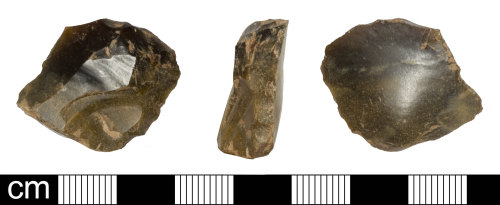
Knapped flint end scraper made on a tertiary flake. It is broadly rectangular in plan with probable breaks down both sides at the proximal end and may originally have been more D-shaped or thumbnail shaped. There is a very prominent bulb of percussion on the ventral face with bulb scars. As well as the breaks on the edges there is a hinge fracture from damage or a failed removal covering the proximal end of the dorsal face. The remaining scars on the dorsal face show previous removals were from a different platform at about 45 degrees.
The retouch extends around the right side of the distal end on the dorsal face. It is long to invasive, sub-parallel and abrupt on the distal end. The distal end is battered from damage or use. The remainder of the distal end and adjacent side is extensively chipped on the ventral face from use. The remaining edges are lost to the breaks mentioned above.
It is 23.0mm long, 28.6mm wide and 8.2mm thick; it weighs 5.43g. The flint is dark grey with mid-grey areas, probably downland flint which has been weathered.
The thickness of the flake and large bulb of percussion suggests hard hammer working and the multi-platform working suggests Bronze Age date, c. 2350 to 800 BC.
Subsequent actions
Subsequent action after recording: Returned to finder
Chronology
Broad period: BRONZE AGE
Period from: BRONZE AGE
Date from: Circa 2350 BC
Date to: Circa 800 BC
Dimensions and weight
Quantity: 1
Length: 23 mm
Width: 28.6 mm
Thickness: 8.2 mm
Weight: 5.43 g
Discovery dates
Date(s) of discovery: Friday 1st March 2013 - Sunday 31st March 2013
Personal details
This information is restricted for your access level.
Other reference numbers
Other reference: SCC reciept 22463
Materials and construction
Primary material: Flint
Manufacture method: Knapped/flaked
Completeness: Incomplete
Spatial metadata
Region: South West (European Region)County or Unitary authority: Somerset (County)
District: West Somerset (District)
Parish or ward: Carhampton (Civil Parish)
Spatial coordinates
4 Figure: ST0043
Four figure Latitude: 51.17746061
Four figure longitude: -3.431953
1:25K map: ST0043
1:10K map: ST04SW
Grid reference source: From a paper map
Unmasked grid reference accurate to a 100 metre square.
References cited
No references cited so far.
Similar objects

Find number: SOM-A7DC09
Object type: DEBITAGE
Broadperiod: NEOLITHIC
Three knapped flint flakes, one with small areas of retouch and possibly originally an unfinished scraper. The crude flake like blade…
Workflow: Awaiting validation![]()
Find number: SOM-6727B5
Object type: FLAKE
Broadperiod: NEOLITHIC
Six fragments of knapped flint flakes/blades probably of Neolithic - Early Bronze Age date. All but one are tertiary pieces.
1. Proximal en…
Workflow: Awaiting validation![]()

Find number: SUSS-8FA3F3
Object type: FLAKE
Broadperiod: PALAEOLITHIC
Later Upper Palaeolithic secondary flake (15,000-8,300 BC). The flake surface shows evidence cortex reforming giving an indication of the age …
Workflow: Awaiting validation![]()
Timeline of associated dates
About Us
About our Site

Find us
The British Museum, Great Russell Street, London WC1B 3DG.
T: +44(0) 20 73238618