
Rights Holder: Birmingham Museums Trust
CC License: ![]()
Image use policy
Our images can be used under a CC BY attribution licence (unless stated otherwise).
BROOCH
Unique ID: WAW-2D9F51
Object type certainty: Certain
Workflow
status: Published ![]()
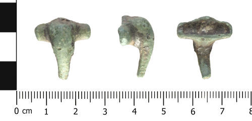
A Roman brooch of Colchester derivative Polden Hill (flat wing ends type, West Midlands) type, cf. Mackreth 2011, 4.a-4.b, 4c, Plate 46, (AD c. 80-120): The brooch is copper alloy and incomplete. The wings are semi-cylindrical terminating with incomplete perforated wing caps. On both sides a ridge is present at the shoulder between the wings and the bow. The wings are undecorated. At the junction of the wings and bow head has the remains of an integral hook which would have held the chord in place. The axis bar, spring and pin are all missing. The bowhead is hump-like in profile and is undecorated. The bow is sub-oval in section, and gradually tapers to break which is recent. On the reverse of the bow, at the junction with the wings there is a patch of white metal alloy, which is quite thick. The surface of the brooch has an incomplete mid-dark brown/green patina. It measures 20.86mm long, 18.5mm wide across the wings and weighs 5.1g.
The brooch is a Polden Hill type. Bayley and Butcher (2004:160) comment that the distribution of Polden Hill brooches are concentrated in the West Midlands and suggest they date to AD 80 to 120.
Bayley and Butcher, 2004 Roman Brooches in Britain: A technological and Typological Study Based on the Richborough Collection Society of Antiquaries
Class:
Colchester derivative Polden Hill (flat wing ends type, West Midlands)
Sub class: Mackreth 2011, 4.a-4.b, 4c, Plate 46
Subsequent actions
Subsequent action after recording: Returned to finder
Chronology
Broad period: ROMAN
Period from: ROMAN
Period to: ROMAN
Date from: Circa AD 80
Date to: Circa AD 120
Dimensions and weight
Quantity: 1
Length: 20.86 mm
Width: 18.5 mm
Weight: 5.1 g
Discovery dates
Date(s) of discovery: Sunday 8th December 2013
Personal details
This information is restricted for your access level.
Materials and construction
Primary material: Copper alloy
Manufacture method: Cast
Completeness: Incomplete
Spatial metadata
Region: West Midlands (European Region)County or Unitary authority: Worcestershire (County)
District: Malvern Hills (District)
Parish or ward: Hallow (Civil Parish)
Spatial coordinates
4 Figure: SO8158
Four figure Latitude: 52.21987801
Four figure longitude: -2.27953953
1:25K map: SO8158
1:10K map: SO85NW
Grid reference source: From finder
Unmasked grid reference accurate to a 10 metre square.
References cited
No references cited so far.
Similar objects

Find number: WAW-6FE418
Object type: BROOCH
Broadperiod: ROMAN
A Roman brooch of Colchester derivative Polden Hill type (flat wing ends type, West Midlands), cf. Mackreth 2011, 4.a-4.b, 4c, Plate 46 (AD c…
Workflow: Published![]()

Find number: WAW-2D0463
Object type: BROOCH
Broadperiod: ROMAN
A Roman brooch of Colchester derivative, Polden Hill (Mackreth Group 4, flat wing ends type, West Midlands), Mackreth 2011, 4.a-4.b, 4c, Plat…
Workflow: Published![]()

Find number: WAW-CA670E
Object type: BROOCH
Broadperiod: ROMAN
A Roman Polden Hill type brooch (AD c. 80-120): The copper alloy brooch is incomplete. The wings are semi-cylindrical, but both are fragmenta…
Workflow: Published![]()
Timeline of associated dates
About Us
About our Site

Find us
The British Museum, Great Russell Street, London WC1B 3DG.
T: +44(0) 20 73238618