
Rights Holder: Birmingham Museums Trust
CC License: ![]()
Image use policy
Our images can be used under a CC BY attribution licence (unless stated otherwise).
KNIFE
Unique ID: WMID-558C98
Object type certainty: Probably
Workflow
status: Awaiting validation ![]()
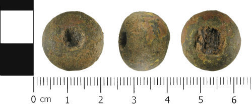
A complete copper alloy, possible end cap from a whittle tang knife, probably of Medieval to Post Medieval dating (13th to 18th Centuries AD).
The end cap is circular in plan, and semi circular in cross section. It consists of a hollow cast copper alloy ball, with an attachment hole extending through the length of the end cap. The hole is circular one side and rectangular on the other. The hole currently contains the remains of an iron tang.
It measures 14.5 mm in height and has a diameter of 19.0 mm. It weighs 9.4 grams.
It is a mid to dark green colour, with an uneven surface patina. Abrasion in a few places has removed the original surface, so it is hard to determine the original function.
The artefact displays similar characteristics as other recorded knife end caps, but due to the abrasion, it is hard to confirm and parallel the identification. It is possible that it could be half of a cast copper alloy bead or weight.
Class: end cap
Subsequent actions
Subsequent action after recording: Returned to finder
Chronology
Broad period: POST MEDIEVAL
Period from: MEDIEVAL
Period to: POST MEDIEVAL
Date from: Circa AD 1200
Date to: Circa AD 1700
Dimensions and weight
Quantity: 1
Length: 14.5 mm
Weight: 9.4 g
Diameter: 19 mm
Discovery dates
Date(s) of discovery: Tuesday 1st October 2013 - Thursday 31st October 2013
Personal details
This information is restricted for your access level.
Materials and construction
Primary material: Copper alloy
Secondary material: Iron
Completeness: Complete
Spatial metadata
Region: West Midlands (European Region)County or Unitary authority: Warwickshire (County)
District: North Warwickshire (District)
Parish or ward: Dordon (Civil Parish)
Spatial coordinates
4 Figure: SK2700
Four figure Latitude: 52.59712744
Four figure longitude: -1.60282227
1:25K map: SK2700
1:10K map: SK20SE
Grid reference source: Centred on field
Unmasked grid reference accurate to a 100 metre square.
References cited
No references cited so far.
Similar objects

Find number: LVPL-86C822
Object type: KNIFE
Broadperiod: POST MEDIEVAL
A complete cast copper alloy, possible end cap from a scale tang knife, probably of Medieval to Post Medieval dating (13th to 18th Centurie…
Workflow: Awaiting validation![]()

Find number: WAW-826F55
Object type: KNIFE
Broadperiod: POST MEDIEVAL
An incomplete cast copper alloy, possible end cap from a scale tang knife, probably of Medieval to Post Medieval dating (13th to 18th Centuri…
Workflow: Awaiting validation![]()

Find number: LON-E30624
Object type: KNIFE
Broadperiod: UNKNOWN
Fragment of an iron whittle tang knife blade. The fragment is concreted and worn, making the original width of the blade hard to determine. Th…
Workflow: Awaiting validation![]()
Timeline of associated dates
About Us
About our Site

Find us
The British Museum, Great Russell Street, London WC1B 3DG.
T: +44(0) 20 73238618