
Rights Holder: West Yorkshire Archaeology Advisory Service
CC License: ![]()
Image use policy
Our images can be used under a CC BY attribution licence (unless stated otherwise).
AXEHEAD ROUGHOUT
Unique ID: SWYOR-B6DE55
Object type certainty: Certain
Workflow
status: Published ![]()
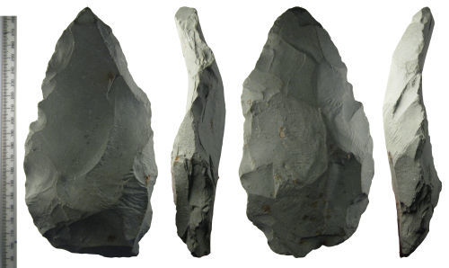
A stone axehead roughout made from Langdale epidotized tuff stone and dating from the Neolithic Period, 4000 BC - 2350 BC. The roughout is ovoid in plan and S-shaped in profile, with a sub-rectangular section.
The roughout has knapped edges and it is roughly axe-shaped, but it was not completed. The faces are still bulbous and the surface is rough: is has not been polished. Work was discontinued and the roughout was discarded for unknown reasons.
The roughout can be compared to LANCUM-5856A2 and LANCUM-799F15 which note that tuff is formed from compressed volcanic ash and has a fine grained composition with infrequent crystalline inclusions. Tuff is found in Britain and Ireland in a band that runs down the Irish Sea from the Lake District (the Langdale's source Group VI), County Antrim (Ireland), through North Wales (Graig Lwyd Group VII), and into Cornwall and Devon (Groups XVI and IV respectively). This roughout was recovered from Langdale, but recent work has shown that as well as petrological Group VI material, the parent rock at Langdale also includes Group XI material, and material similar to Group VIII (Bradley and Edmonds, 1993, 71 - 72). Volcanic tuff is similar to flint in that it can be finely worked, ground and polished to form a variety of tools; however axes are the most common.
Find of note status
This is a find of note and has been designated: County / local importance
Subsequent actions
Subsequent action after recording: Returned to finder
Chronology
Broad period: NEOLITHIC
Period from: NEOLITHIC
Date from: Circa 4000 BC
Date to: Circa 2350 BC
Dimensions and weight
Quantity: 1
Length: 185 mm
Width: 101 mm
Thickness: 33 mm
Weight: 759 g
Discovery dates
Date(s) of discovery: Thursday 1st January 1987 - Friday 1st January 1988
Personal details
This information is restricted for your access level.
Other reference numbers
Other reference: PAS form number 2263
Materials and construction
Primary material: Stone
Manufacture method: Knapped/flaked
Completeness: Complete
Spatial metadata
Region: North West (European Region)County or Unitary authority: Cumbria (County)
District: South Lakeland (District)
Parish or ward: Lakes (Civil Parish)
Spatial coordinates
4 Figure: NY2707
Four figure Latitude: 54.45312256
Four figure longitude: -3.12742329
1:25K map: NY2707
1:10K map: NY20NE
Grid reference source: From finder
Unmasked grid reference accurate to a 1 metre square.
References cited
No references cited so far.
Similar objects

Find number: SWYOR-E70566
Object type: AXEHEAD ROUGHOUT
Broadperiod: NEOLITHIC
A stone axehead roughout made from Langdale epidotized tuff stone and dating from the Neolithic Period, 4000 BC - 2350 BC. The roughout is ov…
Workflow: Published![]()

Find number: LANCUM-AB496F
Object type: AXEHEAD ROUGHOUT
Broadperiod: NEOLITHIC
A stone axehead roughout made from Langdale epidotized tuff stone and dating from the Neolithic Period, 3000 BC - 2350 BC. Lenticular in sect…
Workflow: Awaiting validation![]()

Find number: SWYOR-A3F764
Object type: AXEHEAD
Broadperiod: NEOLITHIC
A stone axehead made from epidotized tuff stone, probably sourced in Langdale, and dating from the Neolithic Period, 4000 BC&n…
Workflow: Awaiting validation![]()
Timeline of associated dates
About Us
About our Site

Find us
The British Museum, Great Russell Street, London WC1B 3DG.
T: +44(0) 20 73238618