
Rights Holder: Birmingham Museums Trust
CC License: ![]()
Image use policy
Our images can be used under a CC BY attribution licence (unless stated otherwise).
SHEET
Unique ID: WMID-B8FC04
Object type certainty: Certain
Workflow
status: Awaiting validation ![]()
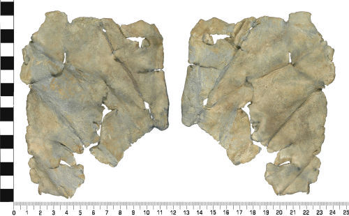
An incomplete sheet of lead or lead alloy metal, of uncertain dating, but probably Medieval to Post Medieval (AD 1400 to AD 1800).
The piece of sheet metal is irregular in plan, and rectangular in section. It was found folded up, but the finder has straightened it, prior to recording. Three sub circular holes are present. Several faint diagonal scratches are present on the surface. These scratches have led the finder to suggest that it may be a 'celtic curse tablet'. However the scratches are not consistent with any known Iron Age script such as Ogham, so the probability that it is a 'celtic curse tablet' is low.
It measures 139.98 mm in length, 110.37 mm wide and 3.93 mm thick. It weighs 190.0 g.
The lead alloy sheet is a mid grey colour, with an uneven surface patina. Abrasion, caused by movement whilst within the plough soil, has resulted in a loss of some of the original surface detail.
It is possible that this lead sheet may have been a curse tablet, but it is more probable that it was originally part of roofing lead, probably of Medieval to Post Medieval dating.
Subsequent actions
Subsequent action after recording: Returned to finder
Chronology
Broad period: POST MEDIEVAL
Period from: MEDIEVAL
Period to: POST MEDIEVAL
Date from: Circa AD 1400
Date to: Circa AD 1800
Dimensions and weight
Quantity: 1
Length: 139.98 mm
Width: 110.37 mm
Thickness: 3.93 mm
Weight: 190 g
Discovery dates
Date(s) of discovery: Sunday 3rd March 2013
Personal details
This information is restricted for your access level.
Materials and construction
Primary material: Lead Alloy
Manufacture method: Hand made
Completeness: Incomplete
Spatial metadata
Region: West Midlands (European Region)County or Unitary authority: Staffordshire (County)
District: Newcastle-under-Lyme (District)
Parish or ward: Silverdale (Civil Parish)
Spatial coordinates
4 Figure: SJ8246
Four figure Latitude: 53.01100127
Four figure longitude: -2.26972474
1:25K map: SJ8246
1:10K map: SJ84NW
Grid reference source: From a paper map
Unmasked grid reference accurate to a 10 metre square.
References cited
No references cited so far.
Similar objects

Find number: GLO-F57380
Object type: CURSE TABLET
Broadperiod: ROMAN
A complete, but worn and corroded rolled strip of lead-alloy of uncertain date, probably a 'Roman curse tablet' (AD 70-410). The objec…
Workflow: Awaiting validation![]()

Find number: NMGW-BECBD3
Object type: UNIDENTIFIED OBJECT
Broadperiod: UNKNOWN
A rolled and folded lead sheet of uncertain dating, probably Roman to Modern (AD 43-1950). The object is roughly tubular in form but appears t…
Workflow: Awaiting validation![]()

Find number: ESS-AD217A
Object type: CURSE TABLET
Broadperiod: UNKNOWN
A complete, but worn rolled strip of lead-alloy of uncertain date, probably a 'Roman curse tablet' (AD 70-410), but also&nbs…
Workflow: Awaiting validation![]()
Timeline of associated dates
About Us
About our Site

Find us
The British Museum, Great Russell Street, London WC1B 3DG.
T: +44(0) 20 73238618