
Rights Holder: Birmingham Museums Trust
CC License: ![]()
Image use policy
Our images can be used under a CC BY attribution licence (unless stated otherwise).
UNIDENTIFIED OBJECT
Unique ID: WMID-7C2485
Object type certainty: Certain
Workflow
status: Awaiting validation ![]()
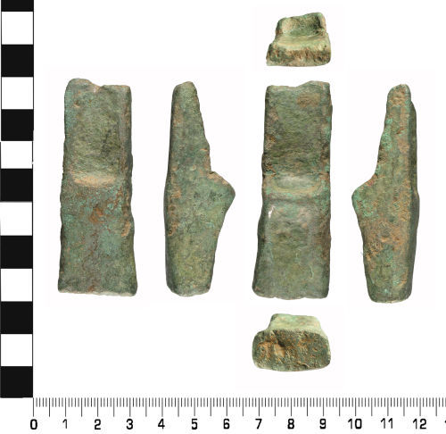
An incomplete copper alloy artefact of uncertain function and dating.
The artefact is sub rectangular in shape, with triangular sides. Both ends are incomplete, with old predepositional breaks. One end is rectangular, the other is sub rectangular with concave faces. In describing the artefact, it can be dividing into two. The top half has concave faces front and back, with a prominent raised stop ridge on the reverse face. The lower half has flat sides which curve upwards to meet the stop ridge on the reverse. The front side is flat with a minimal stop ridge. The sides are flat.
It measures 69.8 mm in length and 24.7 mm wide. It is 7.5 mm thick at the top, 22.6 mm thick in the middle and 14.4 mm thick at the base. It weighs 144.5 g.
The artefact is a mid to dark green colour, with an even surface patina. Abrasion, caused by movement whilst within the plough soil, has resulted in a loss of some of the original surface detail.
No direct parallel has been found for this artefact at the time of recording. It bears a strong resemblence to a palstave but the change of the sides are inconsistent with that identification. Post medieval skillet handle is another possible identification.
Subsequent actions
Subsequent action after recording: Returned to finder
Chronology
Broad period: UNKNOWN
Period from: BRONZE AGE
Period to: POST MEDIEVAL
Date from: Circa 1600 BC
Date to: Circa AD 1900
Dimensions and weight
Quantity: 1
Length: 69.8 mm
Width: 24.7 mm
Thickness: 22.6 mm
Weight: 144.5 g
Personal details
This information is restricted for your access level.
Materials and construction
Spatial metadata
Region: West Midlands (European Region)County or Unitary authority: Staffordshire (County)
District: Lichfield (District)
Parish or ward: Elford (Civil Parish)
Spatial coordinates
4 Figure: SK1909
Four figure Latitude: 52.67837081
Four figure longitude: -1.7204125
1:25K map: SK1909
1:10K map: SK10NE
Grid reference source: From finder
Unmasked grid reference accurate to a 1 metre square.
References cited
No references cited so far.
Similar objects

Find number: HESH-C3EF55
Object type: PALSTAVE
Broadperiod: BRONZE AGE
A cast copper alloy flanged palstave with central rib, possible shield shaped pattern below the stop ridge, and raised flange facets. On both …
Workflow: Awaiting validation![]()

Find number: SWYOR-216933
Object type: PALSTAVE
Broadperiod: BRONZE AGE
A Transitional to late Bronze Age copper-alloy palstave dating from 1150 - 950 BC. It is incomplete, with most of the hafting end missing, an…
Workflow: Awaiting validation![]()

Find number: LVPL-9ED307
Object type: PALSTAVE
Broadperiod: BRONZE AGE
A cast copper alloy (bronze) palstave of Middle Bronze Age dating (c.1500 to c. 1150 BC). The palstave has a shield shaped pattern below the …
Workflow: Awaiting validation![]()
Timeline of associated dates
About Us
About our Site

Find us
The British Museum, Great Russell Street, London WC1B 3DG.
T: +44(0) 20 73238618